Monday, February 28, 2011

Is Blanding really as boring as it sounds (Part 2)?

It's day 2 of my blog trying to find out if Blanding is a boring as its name.  After day 1, my mind was leaning towards 'yes.'

If you have been wondering why a city is named Blanding (as I have), here is the history on the city's name from onlineutah.com:

"First known as Grayson (after Nellie Grayson Lyman...), the town changed its name in 1914 when a wealthy easterner, Thomas F. Bicknell, offered a thousand-volume library to any Utah town that would adopt his name.  Grayson vied with Thurber (now Bicknell) for the prize; the two towns split the books and Grayson assumed Bicknell's wife's maiden name- Blanding.  However, the people of Blanding were somewhat disgruntled to find that many of the books they received were of poor quality."

Today, I decided to check out the Westwater Ruins just outside of Blanding.  These ruins are from the Anasazi cliff culture, so it looks a lot like Mesa Verde, just smaller.  The ruins are right on the edge of town and are easy to get to.  There aren't any signs so the only difficult thing is just finding the right road.  At the end of the road, there is a nice parking lot, with the ruins visible across the tiny canyon.

          Used by permission, Utah State Historical Society, all rights reserved.

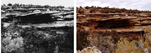
After a quick 5 minute hike down a make-shift trail we got the the ruins.  They were incredible!  I have never seen anything like it.  The ruins are almost exactly the same as they were when they were first being excavated and photographed in 1977. 

           Used by permission, Utah State Historical Society, all rights reserved.

          Used by permission, Utah State Historical Society, all rights reserved.

After looking around for a good 20 minutes, I went to go explore more of the ruins in the canyon.  These are the best looking ones, but there are several Anasazi adobe cliff houses throughout the canyon.  I went up the canyon looking at different ruins and was amazed at what I found.

So is Blanding really as boring as it sounds?  Surprisingly, I am going to say no.  I found myself on the way home wanting to go back and do some more exploring.  I would definitely recommend visiting Blanding, although I think that you should do some research before hand so that you know what you are doing.  Blanding has several old ruins to go scout out all around it.  The one disappointing thing about it though is that I couldn't find any good information about where to find the ruins.  There was information that I found here and there, but not any one great source.  I think that Blanding really has a ton of potential, but should do a better job advertising its potential.  It could be a fun place to visit, but if people don't know what there is there, they won't go.

As for what else is going to happen in the future, I have to take a trip north to Monticello.  There is a little university in Cedar City that I had never heard of before called George Wythe University (click here for more info).  The University recently decided to add a satelite campus in Monticello.  Ground breaking for the campus happened in 2008, but construction was paused due to the economic recession.  The master plan looks stunning, however it will be interesting to see if this develops.  When I was looking on the main page of George Wythe University, some pages regarding the campus in Monicello have been deleted and others funneled me to a page in which I could make a secure donation to the University.  It would be cool though, and I am impressed with the efforts in San Juan County to bring institutions of higher education to the cities around the county.

Sunday, February 27, 2011

Is Blanding really as boring as it sounds (Part 1)?

I spent the last couple of days in Blanding, Utah and decided to take my blog to Southern Utah.  For everyone who doesn't know, Blanding is located in the Southeast corner of Utah.  My expectations for the city were extremely low, especially since its name is Blanding.  It is located between Monticello and Mexican Hat.  How cool can a city be when it surrounded by other cities that are named after Thomas Jefferson's house and a sombrero?  Is Blanding as bland as it sounds?  

As I pulled into the city, the Sinclair station was my first impression


If you're as confused as I was, don't worry.  Yes it does look like in front of the Sinclair has station there is a brontosaurus being humped by a t-rex, being humped by a dragon.  I can't decided whether this is a prank pulled by some local teenagers or if this was actually the intention of the artist.  Whatever it was, the statue stayed like this the whole time I was in the town.

The pictures that I found didn't have any dates on them.  I am guessing that they were from the early 20th Century.  One interesting thing about Blanding is that it was settled by pioneers who traveled through the famed hole in the rock route.  This was the expedition where a group of pioneers descended a canyon with slopes around 45 degrees towards what is now Lake Powell.

The first picture that I came across is the Nilson residence.  This was the first house built in Blanding, and wasn't bad for the first one.  I couldn't find any history on the building and it looks like it hasn't changed much.

          Used by permission, Utah State Historical Society, all rights reserved.

The next building I came across was the Blanding Tabernacle (although it currently has a different name).  Once again, I couldn't find any historical information about this building.  The picture on the left was taken right after construction and before landscaping happened.  So the building is as old as the trees in front.  Any guesses on how old the trees look?

              Used by permission, Utah State Historical Society, all rights reserved.

The final photo is I guess what you would call downtown.  The building on the right was the Grayson Co-op Store, now a True Value.  The building in the middle was demolished, and the building on the left is the bank.  The bank was built either in 1907 or 1909.  It is now a Dryer's Ice Cream Store, which for some reason was closed on a Friday afternoon.  In the picture on the left, a pack of mules is being loaded and taken towards Natural Bridges National Monument.
 
            Used by permission, Utah State Historical Society, all rights reserved.

As for the future developments, there is more sad news.  There is a state park located on the town's border called Edge of the Cedars State Park (I'll be honest, I didn't visit it.  It didn't sound very fun.  Going to see a bunch of cedar trees; I can do that somewhere else).  Recently, the state of Utah was trying to balance its budget after a year in the red.  According to this KSL article, there were 5 different parks around the state that were going to be closed in order to save some extra money, one of which was the Edge of the Cedars.  However in recent developments, the state allocated enough money to keep the park open for an additional year.  It isn't know though if there will be money after this year to continue financing the park.

So is Blanding just bland?  After my first day there, I was thinking the answer was an emphatic yes.  It seems like the town hasn't changed in the last 100 years.  I was impressed to find that the College of Eastern Utah and Utah State University have a very nice campus satellite located in Blanding.  But besides the college, I didn't see anything going for the City.

Stayed tuned for Part 2 for the conclusion of "Is Blanding really as boring as it sounds?".

Thursday, February 24, 2011

Death by Ice Chunks

I came across this picture and really liked it.  It is a picture of Utah Lake with West Mountain (the mountain on the west side of Payson) in the distance from 1927.

Photo courtesy of the L. Tom Perry Special Collections, Brigham Young University

I don't know if anyone has ever been out to Utah Lake in the winter.  There is a really cool beach located on West Geneva Rd south of the Lindon Boat Harbor (if you go looking for it, the road is different than Geneva Rd.  It runs right along the edge of Lake Utah).  I don't know why it happens, but there are huge ice chunks all over the place, gathering in huge mounds.  You can go walk out on it, and even have dinner out there if you'd like, like some have suggested to me.

The same thing happens down by the Provo Airport at the mouth of Provo Bay.  There is a little dirt road that you can access from Provo Center Street just before you cross the Provo River.  If you follow it, it will take you along side the airport, and eventually out to a nice little point jutting out into Utah Lake.  That is where the following picture is taken from.


This winter, the ammount of ice has been exceptionally bad.  The chunks are now piled about 15 feed high onto the road that dikes the airport  resulting in the road's closure.  The following comes from the Mayor's blog about the current situation:   

"After closing the road, we heard from a man who had narrowly escaped disaster earlier in the day. He was ice fishing, and after catching several fish, noticed that the water in the hole was moving very fast. Actually, the ice he was on was moving fast. He knew something wasn't right, so he started to leave. When he got to the dike, the ice had already started to pile up, and pushed a chunk the size of a dog house into his truck causing $5,000 worth of damage. A 20-foot pile of ice now sits where his truck had been parked. Some pieces of ice are16-20 inches thick and as big as the seat of an office chair."

There is some really interesting things happening out by the Provo Airport which you can read about in this Daily Herald article.  Provo has spent millions of dollars on a new radar system for the airport.  They have also invested a lot of money into additional needs, such as fencing around the entire airport, snow plows, and a huge lawn mower to cut the weeds down that grow around the runways.  The goal is to get commercial flights to come to Provo.  Right now, the airport is mainly used for the Utah Valley University flight school and private flights.  However, the mayor has recently been trying to get a commercial airline to do flights directly into Provo.  Who knows what will happen, but may be one day if you are trying to fly to Southern California, you will be able to fly directly into Provo rather than going up to Salt Lake.

Wednesday, February 23, 2011

"A little-known gem in Orem"

A few years back I came across the coolest park in Orem.  Nielsen's Grove is located on Sandhill Rd. (the road next to Wal-Mart) and 2000 S in Orem.  The property was originally bought by Jorgen Christian Nielsen when he immigrated to Utah in the 1870's.  His goal was to recreate a planned, baroque style park based around a fountain which was fed from a natural spring.  All together, the park included a series of gardens, fountains, statues, and even a dance floor.

Around 1910, the park fell into disuse and became a wild swamp.  Around this time, Mary Carter, Nielsen's daughter, moved the swing located at the Grove up to her own property in Provo Canyon at Vivian Park.  Here is a picture of the swing in 1916 in Vivian Park.

Used by permission, Utah State Historical Society, all rights reserved.

Nielsen originally constructed the swing, intending it to be a combination of a swing and a carousel.  Twelve swings hung down from the top.  Located at the center was a cross beam which allowed either a couple of people or a horse to turn the swing in a circle.  This allowed the swings to lift to the side in addition to back and forth. 

I could not find any information about what happened to the original swing.  However, when the city of Orem purchased Nielsen's Grove in 1995, they reconstructed the swing at the park in Orem.  Below is the current state of the swing.


There are only three swings currently rather than 12 but every other aspect is quite similar to the original.  If you have never seen this park, you really should go check it out.  Orem has done a great job recreating Nielsen's original ideas, so much that the Daily Herald stated that the park is "a little-known gem in Orem."

If you want more information about Nielsen's Grove, the city of Orem has created a museum dedicated to the life of Nielsen.  The museum is located in a replica of Nielsen's old farmhouse and is located at the park.  At the museum, you can find replicas of some of the statues that were located in the Grove, an old painting of the park, and lots of additional information regarding the life of Jorgen Nielsen.

Image 

Tuesday, February 22, 2011

The Olmstead

Anyone ever seen the old white building at the mouth of Provo Canyon next to the river trail?  Signs on the road leading to it state "no trespassing."  I have never known what the building was used for, and thought that locals probably had some old lore about how it was haunted.  Today, I found out that that isn't true, and that the buildings are actually part of a hydroelectric power plant called the Olmstead.  Here is the original photo that I found in addition to the current one.  Although there is no date on it, it is probably after 1912

Photo courtesy of the Orem City Library


The Olmstead was originally built in 1903 and replaced the previous hydroelectric plant that was located at Nunn's park.  The plant generated power mainly for mining towns around Eureka.  The plant is currently owned by PacifiCorp and is still in use today.  Water is pumped from the little building at the top of the hill through the long pipes running down the mountainside into the red building on the right.  That is where the hydroelectric generators are, which create energy.  Cool, huh?

I recently heard about a new trail that they are going to put going right around here.  I looked on KSL this morning and there was a whole article about it.  There is a canal, called the Murdock Canal, that runs from the mouth of Provo Canyon up to the Jordan Narrows.  The canal is an open waterway and many people feel that it is dangerous.  Officials from several cities in northern Utah County decided to put the canal underground and then build a 21 mile running path on top of it.  I don't know where the path will be completed, but the pipework should be completed around April of 2012.  This path will link up to the Provo River Trail and will make a really nice addition to trails in Utah county.  For more info about it, click here.

Monday, February 21, 2011

Main and 2nd South in SLC

This blog is called Utah's Present History and up till now, it has been all about Provo.  I was in Salt Lake City on Saturday and decided to take some photos.  I was especially excited about the first photo, which was from on top of the Boston Building, located about 350 S Main St.  The building was closed, but I found a nice fire escape that I was able to grab and climb up.  There were no 'No Trespassing' signs, but I figured it would be okay to take a quick photo.  However, half way up the fire escape, a security guard started shouting at me from the ground, telling me to get off.  I climbing down, and tried to win her over so I could go take the picture.  She wouldn't have it.  She told me that it was unsafe (which is ironic, since the fire escape is supposed to be a safe way to exit the building).  I didn't get the photo, but I'll try again in the future.

The other photo was taken from main street looking west onto 2nd South.  Here is the original from 1907 and what it looks like today:

Used by permission, Utah State Historical Society, all rights reserved.


I tried to locate the Hotel Monaco (the gray building on the left) and the Capitol Theatre (located on the right) in the photo from 1907 since they were the most distinguishable buildings in the area.  When searching the internet I found out that these two buildings didn't exist in 1907.  The Capital Theatre was opened in 1913 (it was probably constructed right after the original photo) and the Hotel Monaco, which is in the Continental Bank Building, was built in 1924.

I did find out some great information on the Continental Bank Building.  It too was highlighted by the Utah Heritage Foundation.  Apparently it was threatened by demolition in the 90's.  It was saved when the property was bought to use as a hotel.  The Utah Heritage Foundation stated, "As this preservation success story illustrates, the problem with "economically unviable" historic buildings often lies in the perception of developers rather than in the buildings themselves."  Often, historic buildings are at risk because they are seen as not profitable.  However with the right mindset, this common perception is found to be untrue.

As for the future of this site, there is an interesting project going on now with the Capitol Theatre.  There is an empty lot just to the west of it.  There are plans for Ballet West to build a dance center.  For more information, click here.  One more thing to add about the Capitol Theatre.  I was really impressed with it, because it has architectural feel very similar to some of the buildings by Gaudí.  Gaudí is a Spanish architect, and has made some of the most interesting, organic, and incredible buildings I have ever seen.  He's amazing.  If you want to see more of his stuff, click here.

Friday, February 18, 2011

University & Center

I recently came across a photo that can be really difficult to place although, ironically, it is probably the most recognized landmark in Provo.  It is none other than the Provo Tabernacle.  Actually, there are two tabernacles in this photo.  The one in front that looks like a cute church meeting house was at the time (between 1890-1910) refered to as the old Provo Tabernacle.  The building in the back ground was the new Provo Tabernacle, or the Tabernacle as we know now today.  Below is the picture that I am referring to and what it looks like today:

Photo courtesy of the L. Tom Perry Special Collections, Brigham Young University


At some point the old Provo Tabernacle was torn down and has now become what is the nice park next to the Nu Skin building.   A few of the other buildings have changed in the picture.  You can see the Nu Skin building peaking out in the background on the right, and the building on the right, where Los Hermanos used to be (sorry I don't know the name of it.  I'm sure I'll figure it out soon) has a completely different facade.  One of the most interesting parts of the Tabernacle is the giant spire in the middle.  Apparently there used to be a huge spire in the middle of the roof.  However, the weight of it made the ceiling colapse, and after it colapsed for the second time they decided to remove it.  Here is a better view of both buildings.

Photo courtesy of the L. Tom Perry Special Collections, Brigham Young University

Unfortunately, the Provo Tabernacle burnt down around 3 months ago.  The big question is whether they will rebuild it (and I sure hope they do).  A security guard located near the burnt out tabernacle told me that there are still investigations going on regarding why the building burnt down, and that they were unsure of what the final plans were.  So as for the future of the Provo Tabernacle, it still remains up in the air.  Let's just hope that it does get rebuilt, because it is such an important part of Provo History (and let's admit it, it is by far the coolest looking building in Provo).


If you want more on the history of the Provo Tabernacle, check out http://www.provotabernacle.org/ or http://saltlakearchitecture.blogspot.com/2011/01/provo-tabernacle.html

Thursday, February 17, 2011

Taylor Brothers Building

Today has probably been the funnest rephotographing yet.  I didn't have very much time today and so I was in a little bit of a crunch.  I did however squeeze in a moment to go rephotograph a picture  from Center St. in Provo.  The only clue I had to its whereabouts was that it was the Taylor Brothers Building on Center between 2nd and 3rd.  There is only one three story building on Center so I decided that it must be the one below.

Photo courtesy of the L. Tom Perry Special Collections, Brigham Young University


As you can tell, this building looks dramatically different from the one above.  There are a few similarities, and when I walked by the building there is a large sign that says Taylor Brothers Building.  However, I got a little confused when I found the following picture.

Photo courtesy of the L. Tom Perry Special Collections, Brigham Young University

This picture was labeled as the Taylor Bros Co. Building.  I thought that may be there were two different buildings, especially since the picture above was labeled as 128 W. Center, which would place it between 1st and 2nd west.  I looked around different buildings on googlemaps for about half an hour to figure out if there were two separate buildings.  Finally, I looked at the two buildings, and I realized that they are identical.  Both pictures come from around 1885.

I finally figured out a little more when I came across the following information from the Utah Heritage Foundation:

 "The historic Taylor Brothers Company Building represents one man's tum-of-the century vision for downtown Provo. Thomas Taylor worked tirelessly to make the west end of Center Street Provo's commercial hub. He twice expanded the Taylor Brothers Building to keep up with improvements in the competing east downtown. With the completion of the second expansion in 1911, the Taylor Brothers Building was the most sophisticated example of commercial architecture in the city.

"When William Bancroft first saw the building, water was falling from the third floor to a large plastic garbage can on the first floor. The elevator was condemned and the building's historic facade was marred by an insensitive 1950s remodel. Bancroft knew the Taylor Brothers Building was for sale and feared that a new owner might tear it down. Motivated by his love of history and vision of the building's potential, Bancroft purchased the Taylor Brothers Building in 1994.

"The first steps in renovating the building were replacing the roof and installing a new elevator. Both proved to be herculean tasks. Restoring the building's facade required removing the 1950s brick arches to expose historic steel columns and uncovering a row of transom windows beneath non-historic signage. The rehabilitation of the building's interior created attractive retail and restaurant space on the first floor and modem offices on the second and third floors."

In 1885, the Taylor Building was 1/3 of its originally length along Provo Center Street.  Even though the front facade looks like one continuous building, from the back it is easy to distinguish that the building was built in three separate stages. Below is another picture that I took of only the Taylor Brothers Building as it looks today.


One cool thing about the old picture I found is to see how much Center Street has changed from 1885.  I think that the Taylor Building is the only structure that still stands from the original photo.  However, it is a really cool structure and I'm glad its stuck around.

Currently, the Utah County Convention Center is being built right next door to this old building.  Also if you look here, it is a link to the Provo City Mayors blog.  He's got an interesting article about an idea that some students from the University of Utah had for the space between the Taylor Building and the new Convention Center.  It will be interesting to see how this block develops over the coming years.

Wednesday, February 16, 2011

Beehive Fountain

Its funny to me how I can pass by a place every day and not even realize that its there.  Yesterday I came across this picture of the Beehive Fountain from around 1920.  The only reason I knew where this was is because the BYU Women's Gymnasium is the the background on the left side.  The Women's Gym is a really cool building on University Avenue that has since become a boutique shop.  Here is the picture form 1920 and what it looks like today:

Photo courtesy of the L. Tom Perry Special Collections, Brigham Young University


The fountain was originally built in 1914.  I really like this picture because it shows some of the good buildings that Provo has preserved.  The current picture is taken from the steps of the Academy Square building, one of the coolest buildings in Provo, which was threatened by demolition in the 1990's.  After its transformation into the library, the statue of Brigham Young was added in front (I believe it is by Dee Jay Bawden.  You cant see it very well, but Brigham Young is standing on the pedestal between the fountain and the street.).

I also took a couple of minutes to figure out some history on the Women's Gymnasium.  Here is an entry from a book I was given about it:

"President Brimhall obtained a [Mormon] Church appropriation for the construction of a large gymnasium-dance hall to be located on the northwest corner of Fifth North and University Avenue.  Ground breaking took place November 6, 1912....  It was later decided to relocate all ladies physical education activities from the Training Building to this new building, and it was therefore referred to as the Ladies Gymnasium....

"Every effort was made in the design of this building to make it good for dancing and gymnasium activities.  Approximately 100 large coil springs supported the entire floor.  It was a good idea in theory, but did not work out as expected.  The movement of the floor sheared off the nails used in construction of the wood floor; and it was necessary to clock up the floor, making the coil springs ineffective."

     The building was later occupied during the army during World War II.  Even though it was called the Women's Gymnasium, several male athletic events took place in the building.  The Gym, along with the Springville High Gym, was used to house the BYU mens basketball team until the construction of the Smith Fieldhouse in the 50s.  The building was sold in 1976, and eventually became Cherry Lane Keepsakes, which is a really cool store for anyone who enjoys knickknack items.

Tuesday, February 15, 2011

Center Street Overpass

Here is the first post of my new blog.  I got the idea while I was in Colorado.  I found a book while at a friends cabin when old photographs where rephotographed.  I loved the idea and wanted to use the same concept with places around Utah.

I love Utah and think that it has a lot of cool unique places.  There is a ton of great history in the Beehive State and I love seeing how that history has developed into the present.  I hope that this blog does a little bit to help preserve some of the great historical places around Utah.

So here is the "Utah's Present History".  This is a picture of the Provo Center St bridge that goes over the railroad tracks from 1930.  It actually looks like quite a pretty little thing, with the decorative lights and cool trees surrounding it.  The picture was taken on the west side of the bridge looking towards the Wasatch front.

Photo courtesy of the Provo City Library


Above is the picture of the current site.  I have to say that they picture isn't entirely fair to this cool piece of Provo since there is lots of construction going on in this area.  And interestingly enough for my first piece, this is one part of Provo history that probably wont be along very much longer.  UDOT has decided to make a new interchange which, from what I can tell, will eventually lead to the demolition of this bridge (for plans, look here).  And even though I completely support the preservation of most historical things around town, I think this is one demolition that I back.  With the current bridge, Center St is a monster to get through, it is often backed up, and whenever I ride my bike over it I am almost positive I am going to get hit by a car.  The new plan appears to have more lanes and make traffic flow easier to the west side of town.

That's it for the first post.  I'll try to do a new one every couple of days and bring photos from interesting places from all around Utah.