Wednesday, June 29, 2011

The Bulloch Mining Claim

     Down by Mount Carmel, on the east side of Zion National Park, there are some really interesting uranium mines.  My friend, Erik, recently featured the mines in his blog Lost and Never Coming Back.  He said that I could use his post and I am excited to talk about this cool place.  Here is what he wrote:

The Bulloch Uranium Mining Claims were started in 1949 by Henry Bulloch (born in Cedar City in 1911).  After World War II and the invention of the nuclear bomb uranium mining became a lucrative business—if
you could find the stuff!

Henry Bulloch married Jean Matheson, the sister of Scott Matheson (later the governor of the State of Utah).  Matheson helped fund Bulloch’s mining claim.

There were three mining claims near Orderville Gulch, Lynn claims 1, 2 and 3.  The 3rd claim was the only to produce significant amounts of uranium ore. There were three main tunnels and several exploration tunnels in the Lynn No. 3 claim, which were started in 1949.  The ore from them was made up of about .20% uranium – a high enough percentage to make a decent profit.

In 1950 Bulloch received a $100,000 grant from the US Government to continue mining.  The mine was open from March to November each year, and at its peak the mine produced about 300,000 tons of ore each year.  The ore was hauled by truck to Kanab and Cedar City where it was then shipped by train to the smelters in California..

The mining claim produced plenty of ore, but the uranium content was not high enough.  Each ton of ore averaged about .12% Uranium, not the .20% they had hoped for.  The mine operated until the end of 1953 when the US Government terminated its contract with Bulloch.  While other uranium mines were producing ore with higher uranium content, there was no need for Bulloch’s uranium mine.

The miners lived in 3 bunk houses, about 1 mile from the mining tunnels. The miners worked 10-12 hour days, 6 days a week.  Because uranium emits radon gas, ventilation was extremely important in uranium mines.  Fans were installed to keep oxygen levels up and radon levels down.  It was later realized that uranium miners developed cancer at a rate much higher than average due to the constant exposure to low levels of radiation.  In 1990 surviving American uranium miners received compensation under the Radiation Exposure Compensation Act.

The miners worked 10-12 hour days, and their pay included room and board.
(Money in parenthesis adjusted for inflation)
5 miners – $12/day  ($107/day)
5 muckers – $10/day ($90/day)
1 hoistman – $10/day ($90/day)
1 Manager – $500/month ($4,500/month)
1 Cook – $8/day ($71/day)

Bunk houses (3) – $500 a piece ($4,500)
Cook Cabin
Storage Tent
Power plant and electric generator (gasoline powered)
One forty ton ore bin
500 gallon Water tank

The three original bunk houses are still standing. 

 The power plant is above the mine tunnels.

The original power generator is still in place.

The caved in entrance to Lynn Claim 3 tunnel 2, the buried entrance to tunnel 1 is to the right.

The entrance to Lynn claim 3 tunnel number 2 has also caved in - there is a very small hole that you could crawl through, but if the mine is as crumbly as the entrance, it's probably not too safe.

The entrance to an exploratory tunnel, with Lynn claim No. 3 tunnel 3 (the deepest tunnel) in the bushes to the right

The entrance to tunnel 3

The tunnel splits about 100 ft into Tunnel 3

Inside one of the exploratory tunnels - it only goes back about 35 feet.

The outhouse is still there

     Thank you Erik for finding out that information!  The bunk houses (and mines which are down a little dirt road to the side of the houses) are located about 8 miles up North Fork Rd. which is located off of Highway 9 just east of Zion National Park.

Monday, June 13, 2011

Pioneer Park in Provo

   Pioneer Park in Provo is one of my favorite areas in Provo, and one of the best parks in town.  The park is one of the oldest in Provo and is over 100 years old.  I found a great picture of it from around the 1920s:

Photo Courtesy of the L. Tom Perry Special Collections, Brigham Young University

Here is what the park looks like currently:


     There are a couple of big differences between the park today and what it looked like almost 100 years ago.  The biggest difference is the pavilion.  There is actually a plaque in front of the current picnic area that commemorates the old pavilion:


     The plaque is a little hard to read in the picture, but it says, "Provo Bandstand, Pioneer Park: Circa 1930-1991 [I found somewhere else that the pavilion was actually built in the 20s, so the construction date is a little questionable]: A grateful community dedicates this marker in honor of the business and professional women's club of Provo.  The Provo bandstand was funded and build under their direction to encourage the public performance of music and the arts.  The many activities held at the bandstand enriched the quality of life in the city which they loved."
     The bandstand was used mainly for concerts.  However, the concerts began to attract more people than the park could handle and they were moved to North Park, located at 500 N 500 W.  After moving the concerts, the bandstand was only used a couple of times a year.  Over time, the bandstand fell into disrepair.  It was eventually described as an eyesore in addition to a safety hazard.

     Around 1991, there was a lot of discussion about the bandstand and whether to renovate it or to construct something completely different (you can find discussion about it here, here, and here).  Provo City Council set aside $15,000 to renovate the bandstand, although it was initially speculated that the renovation would cost around $22,500 (although potentially up to around $40,000).  Provo was having difficulty raising the funds, and due to this and the lack of events being held at the location, Provo City decided to tear down the bandstand and construct a picnic pavilion.  I am a little confused because from what I can tell the cost of constructing the picnic stand came at the same cost of refurbishing the stand.  The compromise by the City Council was to put up a plaque memorializing the stand (which is shown in the photograph above).  The best quote that I found about the demolition of the band stand was from Mike Leventhal, director of the Utah Historical Foundation, who described the demolition and plaque as "we killed your grandmother, but here's a picture of her."
      The other big change involves an old canal that ran through the park.  The canal ran north and south along the east side of Pioneer Park (along 5th W).  The only picture that I could find of it is courtesy of the Daily Herald:


Around 2005, the canal was closed and filled because it was stated as a safety hazard.  However, recently plans have been created to rebuild some type of water feature at Pioneer Park.  The plan is to create a fountain like feature in front of the picnic pavilion (right where the bandstand plaque is currently located).  Construction on the project should be starting shortly, especially since construction is supposed to be completed around the beginning of Fall. It should bring back some excitement to Pioneer Park, and also add a wonderful addition to the Farmer's Market that is located at Pioneer Park and a great place for people to enjoy throughout the summer.

Saturday, June 4, 2011

Historic Homes near Pioneer Park in Provo

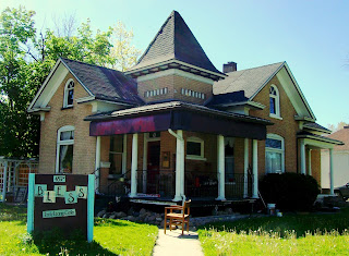
     Today I wanted to focus on a couple of really cool houses that are located just a block away from each other on 100 S.  The first is the Angus Beebe House which is located at 489 W 100 S.  Here is a old photo of the building from the 1940s:

Photo courtesy of http://www.provo.org/index.php?module=ibcms&func=print&fxn=commdev.landmarkslist_main

     The Provo City Landmarks website states, "Built in 1903, the Beebe House is an unadorned example of the pattern book houses popular at the turn-of-the-century. The influence of the Queen Ann Style on this pattern book design is most evident in the square, stubby tower, with bell cast roof which projects through the porch roof and allows for an entry vestibule off the porch. The house was built for Angus G. Beebe, son of a flour-milling family, who was himself employed as bookkeeper of the Provo Roller Mills. The style and substance of the home suggest the aspirations to fashion of many second-generation Provo residents."
     The plaque on the houses states that "the Beebe House is a restrained example of the small, pattern-book house of the Victorian era.  A comprehensive survey of the city of Provo concluded that it is one of the best of only a few remaining examples of this type.  With its arrangement of square corner tower, gables and corner porches, it is the more sophisticated of only two pattern book houses in the city with an entry vestibule int eh corner tower.... Of interest in the interior is the grained interior woodwork.  The oak hardwood flooring is also intact."
     The house is currently used by the Bless Learning Center.  I am not sure what type of company that is, but I often see people out on the lawn doing a garage sale.  Here is what the house currently looks like:


The second building is located at 383 W 100 S, the Richard Hines Mansion.  Here is a photo of the building from the 1940s:

Photo courtesy of http://www.provo.org/index.php?module=ibcms&func=print&fxn=commdev.landmarkslist_main

    The Provo City Landmarks website states about the Hines Mansion, "This home was constructed in 1895 for Russell Spencer Hines, with money acquired from his mining, business and real estate ventures. Hines also owned and operated the Palace Saloon on Center Street. The Hines Mansion is Victorian in style and resembles the Reed Smoot home (183 East 100 South). This suggests that this home may have been designed by Richard K.A. Kletting, a prominent Utah architect who is known to have designed the Smoot home. An Award of Merit was presented by the Utah Heritage Foundation to Douglas K. Hardy for his renovation of the structure between 1975 and 1978. During that three-year period the first level wings were added. The cupola is a representation of the original which was removed many years ago. The Russell Spencer Hines Mansion is presently being used as a bed and breakfast inn." 
     The National Register of Historic Places Plaque on the building states that "After [Spencer Hines'] death in 1898, Kitty Hines [his wife] continued to live in the house until 1906 when it was rented to several individuals including Bert and Sarah Bowen who purchased the house in 1922.  Their daughter, Maude, inherited the house and lived in it with her husband, Benjamin Frank Roper, for 34 years."
     Here is the building as it currently looks:


     The building still looks amazing on the corner of 4th W and 1st S and as was stated earlier, it is currently the location of the Hines Mansion Bed and Breakfast.  Both buildings are on the National Register of Historic Places.  And both are beautiful buildings that will hopefully be preserved for several years in the future.