Although I am not sure that there was some trail from Salt Lake City to Los Angeles in the early 20th century, in 1915 the Arrowhead trail was established as the first all-weather road connecting between the two cities. The road ran through Las Vegas and is now part of what Las Vegas Boulevard. A sign placed by the Nevada State Historical Society says:
"Las Vegans claimed to be the originators of this all-weather route between Los Angeles and Salt Lake City. From the beginning, the Arrowhead Trail was a 'grass roots' effort including promotion by the various chambers of commerce and volunteer construction by local citizens. However, it was Charles H. Bigelow, from Los Angeles, who gave it great publicity. During 1915 and 1916 he drove the entire route many times in his twin-six packard 'Cactus Kate.'"
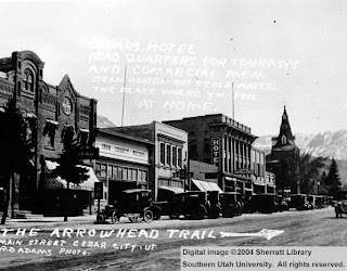
The only picture of the original trail that I could find comes from a section of downtown Cedar City, with the road right right down the middle of town:
Photo courtesy of the library at Souther Utah University
In 1926, when the federal highway numbering system was established, the Arrowhead Trail became Highway 91. From what I can read, Highway 91 followed the same route as the Arrowhead Trail. The road ended in Long Beach, and to the north it went as far as Alberta, Canada. Here is a map of the original Highway 91 from 1926 in addition to a picture of the construction of Highway 91 in Cache County:
Photo courtesy of the website www.wchsutah.org/roads/highway-91.htm
Used by permission, Utah State Historical Society, all rights reserved.
In the 60's and 70's it was decided that a new road needed to be put in its place, which eventually became the I-15. The I-15 covers the same area as Highway 91 and in some areas was built directly on top of it. Two major differences is that it did not go through Logan and also cut through the Virgin River Gorge, making the traveling time from Las Vegas to St. George much quicker. The final section of the road was completed in 1975 and it is currently the 4th longest north-south interstate highway in the US.
After I-15 was built, some areas of Highway 91 fell into disuse. I found a picture of a plane using the old road just north of Cedar City as a runway in 1970:
Photo courtesy of the library at Souther Utah University
For the last 40 years, the I-15 has been the primary north-south viaduct in Utah. In recent years, there has been a large population growth throughout Utah. As part of UDOT's plan to support this growth, there has been lots and lots of construction along the I-15, most recently in Utah County. The construction in Utah County is known as the I-15 Core, which is the largest construction project undertaken by the state of Utah. This project mainly calls for widening the I-15 and using concrete instead of asphalt (which will be great cause it will cut down on potholes), it also includes rebuilding and reconfiguring 10 freeway interchanges and replacing 55 aging bridges. One of these bridges is the Sam White bridge which, at 354 feet long, will be the longest two-span bridge ever moved in the western hemisphere. It is really cool to watch them move it since it is moved into place with huge hydraulic lifts. If you want a movie of it, just click below.
I went the other night to watch another bridge by put in place in Pleasant Grove. It was pretty cool, just to watch the machinery at work and how many people it took to do the whole operation (probably around 100). Here are some pictures from that trip:
I did find some interesting pictures of the Highway 91 as it is today. For a cool website of the old Highway 91 by Idaho area, click here, and for some cool pictures down by St. George, click here.


Next time you're down in Cedar City, you should try to find that same street and add it into this post- it would be super interesting to see.
ReplyDelete