Friday, April 29, 2011

Downtown Eureka (Part 1)

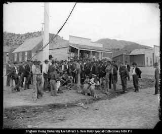
     I love it when I meet nice old people that know a bunch about the history of a place and have nothing better to do than to share it with me.  I found the following picture of downtown Eureka around the turn of the century:


     I couldn't really figure out where there buildings were located but there is really only a couple of blocks where they could be located, around the western most part of Main St.  I decided that the post would work best if split up into two parts (so that's why this is Part 1).  Here are the western most buildings:


     While walking around this area, I met one of the nicest guys that I have ever met.  He owns all of the photos in these buildings and took me on a tour of all of them.  He is working to restore all of them, although he is going really slowly (right now he is in the Marshall Islands for the next 6 months).  Only one of the buildings, the one of the far right (if I remember right, it is the brick building to the right of the light blue building), even looks partially completed.  He would like to open up a restaurant inside; here is a picture of it:


     The green building to the right of the light blue building is the McCornick and Company Bank.  A plaque on the building reads: "This building was constructed in 1909 to serve as the new home of McCornick and Company bankers and has continued to the present to serve as a bank.  McCornick and Company first came to Eureka in 1898, when they moved their bank, fixtures and all, from the mining town of Mercur [located around 15 miles west of Lehi], apparently with the interest of replacing the George Arthur Rice Bank, which had folded in 1897.  Around 1917, Eureka Banking Company took over the building, which gave way to the Commercial Service Company in the 1960s.  The current occupant of the building is First Security Bank."  The plaque was 1985 and contrary to what it says, there is no bank in the building.  There was a bank a couple of years ago, but it moved to Goshen and replaced it with an ATM.
    I then got an amazing tour of the building that says "The Oxford" and the building next to it (the two are connected inside).  Here are some pictures from inside:


     There used to be room located behind the wall where the door is.  This is where they would hide the alcohol during prohibition days.  Just to give you a heads up, pretty much everything that deals with these buildings involves alcohol and prostitutes.  Hey, its a mining town, what do you expect?


     This is a well inside of the building.  The funny thing is that the well has never actually been used for water.  The well was used to hide alcohol when the police came looking during prohibition.
     After we left this building, I was told that we were going to go to a topless bar.  I was really confused (and a little shocked.  I knew that topless bars were really common in Oregon, but I hadn't heard of any in Utah).  I was taken to the building that is right of the thin building with three windows on the top level (which makes it look like a little Spanish building).  Turns out that the bar just doesn't have a roof, which makes it topless.  Here are some of the photos from it:


     This building has a lot of history to it.  It used to be a bar and then a hotel was right above where the miners could go sleep with prostitutes (and that pretty much is the deal with all of the buildings around here).  People used to write their names on the boards in the picture above.  The oldest one that I found is from 1906, which is right below the 1908 on the top board section.  Also there used to be a wall on the right which fell down.  It separated the building from a natural water drainage.  People would use this little alleyway to sneak into the building, and if nothing else, carve their name in the wood.  The building is still being used today for dances, and the guy repairing it hopes to turn it into a dance hall.
     I love Eureka.  Although all of these shops are run down and closed, I was told that the city comes to life around Spring Break.  There is bumper to bumper traffic going through the town trying to get the Little Sahara to go for ATVing at the sand dunes.  I hope that some more economy will come to town so that the buildings will stay kept up for good.

Thursday, April 28, 2011

A Man Named Jolly

     My friend is currently in Southern Utah working near Zion National Park.  He heard an awesome ghost story involving an old cabin down in the area.  Unfortunately I couldn't find any old pictures of the place, but the story was too good to pass up.  Here is what he wrote about it from his blog nevercomingback.net:

     I rode along on an ATV tour our rec director Kourtney was doing. She told us this story during the ride, and it was so awesome, I took Portia out this evening for the same ride.
     Back in the early 1900′s, a man by the name of Jolly (first name or last name? I’m not sure) came to southern Utah early in the spring. Near what is now the East Entrance to Zion National Park, he found a beautiful little canyon where he thought he could make a living raising cattle.


     Soon after, while spring was still springing, Jolly brought his wife and two children to the little canyon, and built a beautiful house next to a cool brook. His cattle happily munched on the green grass and his family began to settle in.


     As spring came to an end, and the scorching summer season began, Jolly and his family were surprised to find that the cool brook slowed to a trickle, turned to moist sand, and quickly dried up. They were far from the Virgin River, and water was no where to be found.
     As the long, hot days passed and they used the last of their water, Jolly realized that he and his family could not survive. They didn’t even have enough water to leave their new home to go get help.
      Finally, his cracked lips spread into a smile, and he unexpectedly invited his wife and children to go for a walk down the dry stream.  They came to what was once a lush waterfall.
     Once there, he threw his wife and children off the cliff and they tumbled to their deaths.  He returned to his house, and wrote down what he had done, and then walked back to the dried up waterfall and threw himself down as well.
     When you stand at the edge of the waterfall (or dry fall), if you feel the wind blowing at your back, that’s Old Man Jolly trying to kill you.  If you feel the wind blowing in your face, that’s his wife trying to save you.


     As the years have gone by, Jolly’s old ranch has changed hands several times. Each owner has tried to repair and remodel the house, as can be seen by the various modern improvements on the house. But each owner has left the house before finishing because the spirits of Jolly and his family still haunt their old home.
When you visit Jolly’s Gully, enjoy the view, but make sure you bring plenty of water!

     Erik took an ATV out to Jolly's Gulch but it is accessible by hiking if you want to visit.  To get to the location, you have to take the East Rim Trail at Zion National Park.  According to information that I found on the internet, the Gulch (and the waterfall, if there is one at the time) are located about 2.8 miles from the East Rim Trailhead at the eastern entrance of Zion National Park.

Wednesday, April 27, 2011

The Great Salt Lake (SLC Downtown Rising)

     Here is an art project that I have been working on the last couple of days.  I took the idea from a roommate who did some tape drawings (using blue painters tape) of Mao, a vespa, and the birth of Venus picture.  I did a picture of Che and Gandhi and wanted to do a picture of downtown Salt Lake City.  I started on a random abandoned wall a few blocks away from my house, but the video didn't turn out so good (and a cop was driving by every 20 minutes to make sure that I wasn't graffiting).  I decided that the best place to do it would be my room.
     I filmed it with my camera that was placed on my roommates dresser.  I did it over two days (at one point it got cold and I put on a sweater, which is why I have on three different things during the video).  I recorded almost 5 hours of video, although it took me a few hours longer since I spent several hours tearing the pieces of tape in half while watching shows (like "My Super Sweet Sixteen" and "Celebrity Apprentice").
     The title is taken from the name of the song that is playing in the video by Band of Horses (it is called The Great Salt Lake) and the Downtown Rising plan which is going on right now in Salt Lake City (you can see posters about it on a lot of the signs downtown).  Hope you enjoy!

Sunday, April 24, 2011

Churches in Eureka

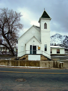
     Continuing with my travels around Eureka, there are some really pretty church buildings around town.  A few buildings west of the City Hall is a old Methodist church building.  Here is a picture of it from around the turn of the century, and what it looks like now:

Used by permission, Utah State Historical Society, all rights reserved.


     The plaque on the building reads: "Constructed in 1891 with funds secured from local Methodists and the Mission Conference of 1890, this building is important in documenting the religious life of Eureka and Tintic.  Methodism began in Tintic when Dr. Thomas C. Iliff visited and preached on June 18, 1890.  Reverend W. A. Hunt was appointed first pastor and succeeded be Dr. J.D. Gillilan who finished the church structure.  The Gothic style tower houses the original bell."
     To the east of the Methodist Church stands the old Mormon church.  Here is a picture of it also from around the turn of the century in addition to what it looks like today:

Used by permission, Utah State Historical Society, all rights reserved.


     The plaque on the building reads: "This building, designed by architect Richard C. Watkins, served as the Eureka L.D.S. Ward Meetinghouse from its construction in 1902 until 1976.  It was dedicated in 1903 by Apostle Reed Smoot [who was the first Mormon Senator from the state of Utah.  He's got a really interesting history, and was almost kicked out of the Senate for being a Mormon Apostle.  I just finished a really interesting book about it called The Politics of American Religious Identity: The Seating of Senator Reed Smoot, Mormon Apostle.  You can read a short summary of it by clicking here.].  The Gothic Revival Style building has been an important park of the religious history of the Tintic Mining Area.  The structure, including windows and the tower which had been changed, was restored by the Ferrel Thomas family in 1988."
      I also wanted to include a tiny building located between the Methodist Church and the City Hall.  It is the Tintic Mining Museum (and no, it was not open).  Here are a couple of pictures of it (I really just like the old mining equipment located in front.  It looks really cool):


Saturday, April 23, 2011

I've found it!

     Eureka, I've found it (if you don't know, Eureka means "I've found it."  Eureka is also the state motto of California, and since I grew up a geography nerd in California, I always knew the meaning of Eureka).  I've got to say, I think that Eureka may be one of the coolest little towns around Utah.  Most of the downtown has been on the National Register of Historic Places since 1979, which makes it a cool place because it has preserved most of its mining day charm (and will continue to preserve that charm since these buildings can't be destroyed).  But before I get too far ahead of myself, I should at least give a little history on Eureka.
     Eureka's history is totally tied with mining.  The wikipedia article on it says: "Eureka was originally known as Ruby Hollow before it developed into a bustling mining town. Incorporated as a city in 1892, Eureka became the financial center for the Tintic Mining District, a wealthy gold and silver mining area in Utah and Juab counties. The district was organized in 1869 and by 1899 became one of the top mineral producing areas in Utah. Eureka housed the "Big Four" mines—Bullion Beck and Champion, Centennial Eureka, Eureka Hill, and Gemini-and later the Chief Consolidated Mining Company.
     "Eureka's role as the central financial point for the district ensured its survival. It housed business establishments, including the second-ever JCPenney store (then called the Golden Rule Store), financial institutions, local and county governmental buildings including Eureka City Hall (1899) and a Juab County Courthouse (1892), various churches, and the meeting places for numerous labor, social, and fraternal organizations."
     You may have heard me mention discussion about the Tintic Mining area in the previous posts about Silver City and Mammoth.  All of these cities were mining towns and an important part of the mining history in Utah.  Eventually six different communities were settled after the discovery of gold in 1869.  At the turn of the century, Eureka was the 9th biggest city in the state with around 3,000 people.  One of the cool photos from this time is of the City Hall:

Used by permission, Utah State Historical Society, all rights reserved.

     If you haven't noticed from the previous posts, the entire Tintic Mining Area has seen a big decline since its heyday.  Eureka now has a little more than 700 people living there, and most of downtown is closed.  Many of these buildings are in desperate need of repair and are currently not being used.  Here is the current picture of city hall:


     The building is pretty similar to how it looked over 100 years ago, with a few minor alterations to the roof and the balcony above the door.  The plaque on the building says: "The Eureka City Hall was built in 1899 by the Eureka City government and functioned as the offices for city court, mayor, sheriff, recorder, treasurer, council chamber and city volunteer fire department.  John K Pilgrim, a city official, drew the plans and specifications for $100 and Adams and Sons of Eureka built it for $4,400.  Eureka City Hall still serves the same function except the courtroom and most of the second floor now house the Tintic Mining Museum sponsored by the Tintic Historical Society.  it was listed in the National Register of Historic Places on March 14, 1979, as part of the Eureka Historic District."
     I am a little confused as to this museum and the other one that is located in town.  Both were closed.  When I talked to a local, he said that most shops along the historic avenue were closed (except for an occasional gun shop that opened, a gas station, and a consignment shop that was only occasionally open).  He said that during the summer the streets are packed with people heading towards Little Sahara to do some four wheeling.  May be during the winter, when nothing is happening in the city, all of the museums close down?  I really like the feel in the town and would like to help out restoring and repairing some of these cool buildings.  Hopefully as I have the chance to do this and visit Eureka more often I will finally find out.

Thursday, April 21, 2011

The Cabin of the "Destroying Angel"

     Today's entry came as a surprise to me.  I was traveling around Eureka when I came across Porter Rockwell's cabin.  It was especially odd to me as a couple of days before I had just been discussing Porter Rockwell in another post involving Brigham Young's bodyguard.  Since I didn't know anything about this cabin and since I don't know much about Rockwell, most of this history is going to be taken from what I found in Eureka (which was posted on a board next to the cabin).
     "Orin Porter Rockwell was born on June 28, 1813 in Belcher, Hampshire county, Massachusetts to Orin Rockwell and Sarah Witt Rockwell....
     "Known as the 'Destroying Angel' he was bodyguard to the [Mormon] prophet Joseph Smith and later to Brigham Young.
     "Porter had a ranch west of Cherry Creek, known as Rockwell's Ranch.  It is from this ranch that we obtained the cabin.
     "Porter was said to have lived in the cabin south of the ranch house hear a big pond and lots of water.  During winter, blocks of ice were cut from the pond and stored in an ice house, built with thick walls filled with sawdust for use in the summer months.  Porter had a nice orchard and grew cantaloupe and watermelons.  Rumor has it that at night he would walk around the cabin and orchard [unreadable text] to himself. Some say he talked to 'ghosts'.
     "Orin Porter Rockwell died on June 9, 1878 in Salt Lake City of natural causes and was buried in a Salt Lake City cemetery."
     I had never heard of Cherry Creek but I believe that it is west of Little Sahara National Recreation Area (for some cool pictures of the area, click here).  The cabin was built in 1865 and I couldn't find any information regarding when exactly it was moved to Eureka.  Here are a couple of pictures of it when it used to be at Cherry Creek (by the way, sorry for the reflection in the pictures):


     The cabin currently sits right Main St. in Eureka.  Here are some pictures of it:


     If you are wondering why the cabin is sitting next to a building that looks like it was bombed, don't worry, I'll get to that in some later posts (just as a quick answer, Eureka's downtown is a little run down, as you can see in this picture).  I've gotta say that Porter Rockwell is one of the scariest people that I have ever seen (if you don't believe me, click here.  He looks like death).  The picture of him on the rock (as seen in the first photo) doesn't really help for his scary image.
     If you would like to learn a little more about this cabin, you can watch a youtube video touring the inside of it.

Tuesday, April 19, 2011

The Old Glory Hole

     Continuing on with the ghost town theme, today I am still in the Tintic Mining District, between Silver City and Eureka.  I found this cool photo of the Tintic Hospital located in Mammoth from probably around 1910:


     Mammoth was settled shortly after the discovery of the Mammoth Mine in 1870.  The mine was nicknamed "the old glory hole."  People quickly came to the town, although it was difficult to settle since there was no water located in the vicinity (residents had to buy drinking water for ten cents a gallon, which I think is better than Silver City, which, if I remember right, sold water at a dollar a gallon).  The Mammoth Mine produced ore, silver and gold.
     Wikipedia states that "activity in Mammoth peaked around 1900–1910, with a population of 2500–3000. The town had a school, four large hotels, and other businesses typical of a town its size. Mammoth was officially incorporated in 1910, but began to decline soon after. By 1930 the population was down to 750, the town having disincorporated on 29 November 1929."
      As far as the hospital goes, the history of it is found on the plaque that currently is located at the site of the hospital.  It reads: "Vicinity of 800 W Main Street, Mammoth, Juab County, Utah.  Built as a boarding house in 1893 and converted to a hospital in 1902.  The Tintic Hospital served the people of the Tintic mining district until 1938.  Originally operated by Drs. Mott, Townsend and Stephens.  It was purchased by Dr. Steele Baley Sr. and Dr. Charles Harvielle in 1904.  Dr. Steele Baley Jr., who at the time was attending medical school, later joined his father and brother-in-law in the practice of medicine in 1904.  He continued to operate the hospital until 1933 when he moved to Eureka, Utah.  The services rendered to the people of the district during the influenza epidemic of 1918 will long be remembered, as also the numerous emergency treatments given the miners and their families of the district.  The original building was destroyed about 1935."
     Mammoth is now classified as a partial ghost town as there are still people who live in the town (I found one individual who said there were 18 people living there, although this person also said that at the turn of the century Mammoth and Eureka were the largest cities in the state.  They were not.  The cities were probably around the 9th and 10th largest in the state, which is saying something for cities that are now basically considered ghost towns).  The area where the hospital was located is now an empty lot with a plaque dedicated to the hospital.  Here is the photo of the lot, in addition to some other photos from around the town:

(the plaque and stone structure where it is located can be found on the left side of the photo, between the left mountain peak and the road)


     The final picture is of the Mammoth Fire Station which is on the National Register of Historic Places.  A plaque on the building reads: "This structure, constructed c. 1930, is significant for its association with the history of firefighting in Mammoth.  In August 1912, the Mammoth City Council organized a volunteer firefighting unity, and on August 27, 1812, the first meeting of the Mammoth City Volunteer Fire Department No. 1 was held.  In December 1930, their name changed to the Juab County Fire Department.  This building, built of brick, remains an example of the commercial style of architecture in Mammoth.  It continues to serve the firefighting needs of Mammoth.  The Mammoth Fire Station was listed on the National Register, March 14, 1979, as part of the Mammoth Historic District."
     Mammoth is a partial ghost town because there is still mining that occurs in the town.  On the eastern side, above the rest of the town, is located a coal mining community just below the mines.  Here are some photos from the area:


     In the second photo, if you look closely, there is a 'M' for Mammoth on the hill  Also in the final photo, you can see what I think is the mine opening (or just a really big cave).  If is to the right of the wooden building up on the hill and is kind of blocked by some trees.
     For a great picture of the mine, click here, and for some interesting history, poems, and stories of the town written by someone who lived in the city, click here.

Monday, April 18, 2011

Silver City

     I wanted to continue today on my ghost town theme.  Last week, I had a couple of days off and I got to check out a bunch of ghost towns located less than an hour away from where I live.  I came across some really cool, especially Silver City.  Here are a couple of pictures of it from around 1896:

photo courtesy of utahghosttowns.com 

Photo courtesy of L. Tom Perry Special Collection, Brigham Young University 

Photo courtesy of L. Tom Perry Special Collection, Brigham Young University 

     Silver City was settled around 1870.  Although old Native American mines were found around the settlement, growth was slow due to tales of larger mines around Alta and Park City.  Wikipedia states that since the city lacked "the pacer deposits of many Utah mines, extracting Silver City's riches required labor-intensive hard rock mining.  Early on, mine owners lacked capital and could develop the mines only slowly.  Gradually the town grew from a mere tent city with a saloon and a blacksmith shop, to include a claims recorder and assay office, a telegraph branch, stagecoach line, and post office, and eventually numerous stores, hotels, and restaurants.  There were even two railroad depots, as both the Salt Lake and Western Railroad and the Tintic Range Railroad ran lines into town.  Economic conditions improved, and by 1899 Silver City's population reached 800.
     "In the 1890s, just as the mine companies seemed to be locating the richest ore bodies, a new difficult arose: the mine shafts started filling with water.  As the more marginal mines flooded and closed, while the richest ones continued operating with the help of expensive pumps, Silver City began to dwindle.  Miners left in even greater numbers after a 1902 fire devastated the town.... 
     "In 1908 Jesse Knight, already a successful mine owner in the Tintic area, revitalized Silver City by establishing the Utah Ore Sampling Company and the Tintic smelter here.  He nearly transformed Silver City into a company town, but for the fact that he didn't own the land.  Knight built a power plant, some 100 new homes, and yet another railroad, called the Eureka Hill Railroad.  By 1908 Silver City's population surged to its peak of 1500, most of them Knight employees....
     "Silver City's resurgence was short-lived.  Due to dropping freight rates, Knight's smelter proved unable to compete with those in the Salt Lake Valley.  Records show that by 1912 the population was already down to 300, and there were only 8 businesses left.  In 1915 the smelter was shut down and moved to Murray.  Silver City's decline is often considered to have been complete by 1930, but it was still a separate precinct in the 1940 census, which recorded a population of 111."  It is currently uninhabited.
     I found a great site, utahghosttowns.com, which reported that there was recently a grass fire in Silver City.  It was reported that "the fire destroyed all remaining wooden structures but it also took away most of the weeds and sagebrush.  Foundations, footings, and rubble that had been obscured by undergrowth for years was again made visible.  The fire provided a bonanza for treasure hunters with metal detectors."  Here is the town as it is currently found:

photo courtesy of utahghosttowns.com 


     If you google Silver City, you will come up with an actual location about 2 miles south of Eureka, Utah.  There are no paved roads, just dirt ones leading to what was the town.  The top photo from utahghosttowns.com was taken in 2004 and the trailer that is in the distance has since been destroyed, although the rubble is still there.  The only distinguishing landmark is the blue shed that is found in the second and third photos.  There are foundations all over the place, although few of them are as good as the foundations in the third and fourth photos.  The final photo is a rephotograph of the third picture from 1986 (a lot has changed).  Also in my final photo you can see part of the current mining operation which is happening on the hill that is furthest to the right.  That is where I found this cool old mining machine:


     It is technically private property, but the people that I found there were very kind and directed me to where the town is located.  Apparently there is also an old cemetery located about 2 miles south of Silver City.  I didn't learn about this until today so I don't know exactly where it is located.
     It is a really cool place for people who like to hunt around ghost towns, but do so at your own risk.  Also, if you would like to see some more cool photos of Silver City or read more about ghost towns in Utah, click here.

Wednesday, April 13, 2011

The Ghost Town in Utah County You Probably Never Knew Existed

     I have kind of been on a Ghost Town kick for the past couple of weeks.  It all started when I was just surfing the web and I came across an incredibly interesting story about a Ghost Town on the west side of Utah Lake.  I love living in an area where I think that I know everything about its history, only to find out that there is some cool abandoned town just a few miles away (if you go as the crow flies.  Since I had to drive around Utah Lake, it is more like 30).
     In 1909 Joseph Simpson, R. E. Morrison, and J. E. Davis purchased a 6,880-acre tract of land from the Utah State Land Board for $2.50 per acre.  Their idea was to develop an agricultural community on the western side of Lake Utah.  Much of the land on the western side of the lake is fertile, however it was never settled since there are no rivers on that side of the lake.  Morrison, Simpson, and Davis came up with the perfect name for the community: Mosida (which combined the first two letters of each of their last names).
     During late 1909 through 1911 the area was cultivated in order to support the peach orchards which were envisioned for the area.  Irrigation ditches were dug and a pump house was built which would pump water to the area.  By 1912, 8,000 acres of land had been plowed, 50,000 fruit trees planted, 50,000 bushels of grain harvested (the Provo Herald wrote that "the great sagebrush place has been transformed into orchards and grain."), and a 25-room luxury hotel was constructed.  The hotel was one of the crowning points of the company to lure potential people to Mosida, and it was supposedly one of the best establishments between Salt Lake City and Los Angeles.  Another luxury enjoyed was a ferry which shipped people between Mosida and Provo, which additionally served as a place for dance parties. The Mosida Fruit Lands Company soon added more houses, a store, a post office, and even a school. They imported two French cooks to provide their workers the best of meals at the boarding house.  By 1913 some 400 people had moved to Mosida and were working the farms and orchards.  Here are some pictures of the community:

 Photo courtesy of waterhistory.org


 Photo courtesy of waterhistory.org

 Photo courtesy of waterhistory.org

     However, the whole endeavor quickly turned sour.  The fruit trees began to die as the soil was too salty.  Although some crops, such as grain, did do well in the area, grasshoppers ate them all.  In late 1913 the ferry burnt and transportation to and from the city became extremely difficult.  Pumping the water turned out to be more difficult, especially with the fluctuating levels of Lake Utah.  In 1915, the levels dropped so low that water could no longer be pumped.  The Mosida Fruit Company fell further and further into debt and people slowly left the city.  There were ideas to revive agriculture with sugar beets, but transportation to a market was difficult, especially in winter when the lake froze over.  By 1920 the population had fallen to 67 and by 1924 the town was officially deserted.
     All that is left of the town are a few foundations (such as the foundation of the hotel) and the remains of some other buildings.  Here are some pictures from 1984:

  Photo courtesy of waterhistory.org

 Photo courtesy of waterhistory.org

     I went yesterday to take these photos.  I didn't really know where Mosida was located and I just thought that it was somewhere right off Highway 68.  I drove to about mile marker 15 (I later came to find out that the town is located around mile 12) and asked a man if he could direct me towards the town.  He was very antagonistic and wouldn't tell me at all where it was located.  He said that he was subleasing the property and that he didn't want people to bother it.  He said that he could see the property from where we were, but refused to give any hints as to its location. 
     Unfortunately, the community is not located right on Highway 68 but somewhere closer to the lake.  All the land is private and there are "No Trespassing" signs everywhere!  I wasn't able to find the town and I don't know what shape it is in.  I did find the GPS coordinates (40°07′38″N 111°57′24″W) on Wikipedia if anyone wants to go looking.  Also if you'd like to read more on Mosida, read this Wikipedia article or this amazing history from waterhistory.org.
    While researching Mosida, I did find a really interesting website about a development project going on in Mosida called Mosida Orchards.  There are plans to build a develop a huge community on the west side of the lake right at where the old endeavor failed.  At first I thought that it was just a nice idea, but if you click on the button to find out the property that is available for sale, most of the property has been sold.  I guess that it is going to happen.  I think that this endeavor will definitely be more successful than in the past.  However, I just hope that if it does go through, it wont lead to a bridge going across the lake.  Here is a picture of the area that is planned for development: