Friday, March 11, 2011

Spanish Fork Churchs and Schools

Today is all about historic churches and schools in Spanish Fork.  I thought about doing this in two different posts, but the two things were so connected.  I ended up deciding to just do them together. 

The first church and school that I want to focus on is right at the center of town.  Here is a picture from 1914 and what the location looks like today.

Photo courtesy of the website www.bobcatsworld.com/family/hansenfamily.htm


I couldn't find anything about this church building.  It looked beautiful, but has since been torn down and replaced with a pretty generic church building.  To the right of the church building is the Thurber School, which was constructed in 1910.  I couldn't find any information online about when it closed down, but the building was eventually turned into the Spanish Fork city offices.  Out of all of the buildings in today's blog, the Thurber School is the only one that still is around.  I was disappointed in how few of the buildings have been preserved in Spanish Fork.  I did find an interesting note about Thurber School written by a student who previously attended the school: "While attending the Thurber School I took part in planting a tree on the North East Lawn for Arbor Day.  Along with the tree planting was included a time capsule box... I was wondering if the box had ever been dug up and opened?"  I guess it's a task for anyone looking for an adventure.

Here is what Thurber School currently looks like:


The next school is just a short walk down the street to the south.  I found a great picture of what Spanish Fork High School looked like in 1914.  Here is the picture and what it looks like today

Used by permission, Utah State Historical Society, all rights reserved.


I have to thank Mark A. McKell who I visited while in Spanish Fork.  He helped me to located several of these buildings including this one, which was especially difficult since many of them are no longer there.

The old high school was demolished and in its place is the Nebo School District building.  Once again I couldn't find information about when it was demolished.  Mr. McKell told me that he went to high school in the old building, and that they used to have tug-of-wars between the juniors and seniors across the stream just to the south of this building.  To the right of the Nebo School District building is the Spanish Fork High School Gym.  This gym is a on the National Register of Historical Places (if you would like a complete list of the national register for historical places in Utah, click here).  However, it isn't even in the original photo, since it was built until 20 years after the first photo was taken.

For the final photo, we've got the 1st ward school building.  Here is the original photo and the location as it looks today:

Used by permission, Utah State Historical Society, all rights reserved.


The school was located on the corner of 5th east and center.  The lady who lives on the corner confirmed that there was a school that once was located on the corner.  Since the school was listed as the 1st ward school, I figured that the 1st ward building was located next to it.  Here is the picture of the 1st ward building from between 1892-1920:

Used by permission, Utah State Historical Society, all rights reserved.

Thursday, March 10, 2011

Spanish Fork Flour Mills

Continuing on with Spanish Fork, today we are going to the old grist mill.  For everyone who doesn't know what grist is (to which I would include myself), it is essentially grain that can be ground into different things, such as flour.  The cool thing about this site is that I actually found two photos that I didn't know were of the same place until I went to take the picture and read a plaque about the site.  Here are the two pictures, the first from 1874-1888 and the second from1888-1927, and what the site looks like today.


Photo courtesy of the L. Tom Perry Special Collections, Brigham Young University

Photo courtesy of the L. Tom Perry Special Collections, Brigham Young University


The plaque says, "Spanish Fork was settled in 1857.  The first flour mill was built by Archibald Gardner in 1858-59.  The water for the mill came from the Spanish Fork River.  The stream was enlarged to give sufficient power to run the mill.  This mill was constructed of rough lumber...

Gardner sold the mill to the Spanish Fork Co-op in 1874.  Shortly after it was torn down, it was replaced by a larger, two-story building with more advanced equipment.  This mill was built of shiplap lumber with gables facing north and south.  The flumes carried water to the mill wheel, with a fall of twenty feet.  Flour was made in the mill for fourteen years until April 15, 1888, when it burned to the ground, probably from spontaneous combustion.

Within a short time, a four-story brick building was started at a cost of $40,000.  New machinery was installed, and large steel rollers replaced stone burrs.  The new mill burned in December 1927.  It was never rebuilt.  Today nothing remains of the once busy whirring mill."

Like the plaque states, there is nothing where the old mill used to be located.  The property is part of what is now the  Spanish Fork fairgrounds.  I have been meaning to go and watch the rodeo for the last few years.  I've heard its a lot of fun.  Also, probably the coolest festival, the Festival of Colors, happens just down the road from here at the Hari Krishna temple.  Shuttles are provided from the Spanish Fork fairgrounds.  The Festival of Colors celebrates the coming of spring and thousands of people gather to throw colored flour on each other.  This years festival is bigger than ever (every year it gets bigger and bigger and more crazy than ever) and is happening Saturday, March 26th from 10 am-8pm and March 27th from noon-4 pm with color throwing happening every two hours.  If you miss it, you will be really disappointed, especially cause all of your friends will have cool facebook profile pictures where they are covered in pink, green, and yellow dust.  I can almost feel the suffocating taste of flour in the air as I am writing this.

Tuesday, March 8, 2011

A little bit of Iceland in Utah

As I was searching through photos of Spanish Fork, I came across one of the most unusual photos that I have seen.  Here it is and what the location looks like today:

Used by permission, Utah State Historical Society, all rights reserved.


The older photo is a picture of an Icelandic family standing next to some common Americana figures, such as Uncle Sam, dedicating the Icelandic Monument at 400 South 800 East on August 2nd, 1938.  The plaque on the monument says, "Leif Eiriksson, an Icelander, discovered America in 1000 A.D.  Eight centuries later, 1855-1860, sixteen pioneers from Iceland established in Spanish Fork the first permanent Icelandic settlement in the United States."

Icelandic pioneers settling Spanish Fork led me to be pretty confused.  I always thought that Spanish Fork was obviously named after the Spanish, not the Icelandic, otherwise it would be called Icelandic Fork.  If it was named after the icelandic people, it probably would have a really cool looking name that no one could pronounce like Reykjavík, Kjósarhreppur, or Hafnarfjörður. 

I figured out a little bit of history from the Spanish Fork Wikipedia article.  Spanish Fork was named after the two Spanish friars, Silvestre Vélez de Escalante and Francisco Atanasio Domínguez, who traveled down Spanish Fork Canyon in search of a new route to California from New Mexico (they must have been a little crazy because Spanish Fork is not on the way from New Mexico to the missions in California).  Later the area was settled by Mormon pioneers and eventually people from Iceland.  However, they named it Spanish Fork in memory of Escalante and Dominguez.  One other interesting fact about Spanish Fork: the city is also known for the 1965 Treaty of Spanish Fork in which the Ute Indians were forced by Lincoln's executive order to relocate to the Uintah Basin.

The monument has done a very good job of documenting the Icelanders trek to Utah as Mormon pioneers.  The first Icelanders were converted to Mormonism while in Copenhagen, Denmark and returned to Iceland to tell others about Mormonism.  There is a place in Iceland where several individuals were baptized which is now known as Mormon Pond.  A rock was taken from the pond and now stands at the monument.  It took around 300 days to travel from Iceland to Utah via England, then New Orleans, up the Mississippi River, and eventually to Utah by wagon or handcart.  Around 400 individuals made the trip.  While in Utah, some Icelanders converted to Lutheranism, and both the Lutheran and Mormon churches had services in Icelandic and English due to several individuals having trouble learning English.  It was said that the individuals from Iceland held onto their culture better than any other group of people in Utah.

Spanish Fork still holds an annual Icelandic Days Festival.  They are held on the fourth Saturday in June.  The event is sponsored by the Icelandic Association of Utah which was founded in 1897.  They chose June because Iceland's Independence Day is June 17th.  I believe that there is usually a fair held at the park at 100 South Main in Spanish Fork.  Last year, part of the fair included a project which intended to restore the Puffin to its natural habitat in Maine.  Seems like a good cause, even though it does sound a little random.  There is also an annual Viking feast in Spanish fork that happens in February called Þorrablót.  The meal includes shark, dried fish, sheep, sweetened rutabagas and Scandinavian cake.  Here is the link to the Deseret News article about it from 2010 and a link to the 2011 feast.

For any additional questions about the Icelanders that settled in Utah, contact David A. Ashby at DAA@q.com.

Monday, March 7, 2011

There's Gold in Dem Hills

I am really excited today to highlight the Salem Dream Mine (also known as the Salem Relief Mine).  Salem is located south of Spanish Fork (the Hari Krishna temple, where the annual color fest occurs, is right on the Salem border).  It is a really cool town with an awesome pond (although last year there was some bacteria in it so it was suggested not to swim there.  It is my favorite place to practice for triathlon swims and hopefully it is clean by now).  Here is a picture overlooking the south end of the Valley looking towards the area that is now Salem and what it looks like today:

Used by permission, Utah State Historical Society, all rights reserved.


The Salem Dream Mine is located a little left of where the picture is taken.  Anyone ever noticed the big white building on the hillside near Spanish Fork?  It is about 4 stories tall and is a tiered building built into the mountainside.  I often hear people wonder what it is.  Well, today you are going to find out.  Here are a couple of pictures from it:


In 1864, a man named John Koyle was born in Spanish Fork, Utah.  He was revered in the town as someone who had visions which often came true.  In 1894 he had a vision in which Moroni (Mormons believe in the Book of Mormon in addition to the Bible.  Moroni was the last person who wrote in the Book of Mormon and it is believed by the Mormon church that Moroni appeared to Joseph Smith and showed him where some gold plates were located that would eventually become the Book of Mormon) appeared to him and told him that there was gold located in the hills just to the east.

Moroni told Koyle that there were rooms of gold.  He was told that this gold would be used to help out the people in a time of need.  From stories that I have heard from locals, the gold would be used in the last days (the days before the second coming of Christ) to prevent the United States economy from crashing.  It is because of this that the mine is often referred to as the Relief Mine.  The dream/vision was repeated to Koyle three times.  Digging began in 1894, after Koyle's friends were convinced when Koyle prophesied about a well filling with water.  The well filled with water just as Koyle stated.  In 1909 the Koyle Mining Company was formed with 114,000 shares of stock issued at $1.00 per share.

I read an article about how the Dream Mine was the least profitable mine in the United States.  The mine is around a mile long and supposedly gold was never found.  However, I talked with the guy that is in charge of the mines stock (yes, you can still buy stock in the mine.  I hear that it is actually hard to get and currently sells for somewhere around $33 dollars a share) who said that gold was found.  He said that while digging, an underground spring was hit, which filled the mine up with water.  This caused the gold to be inaccessible.  However, Koyle prophesied that in the last days, there would be a huge earthquake which would cause the mine to drain (I have been told that the mountain will split, which will drain the mine).  This would allow people to go into the mine and gather what gold is there.

Koyle and partners continued to mine, looking for the gold.  Koyle had several other revelations which apparently came true.  One that I often hear about is a revelation where he stated that when mining, they would find a group of rocks on the wall that looked exactly like a map of the United States.  According to tradition, they did find such a group of rocks.  Koyle was the bishop, the leader of a Mormon congregation, of the the Leland Ward; Leland is located near where the sugar beet factory is.  The mine and Koyle's visions attracted the attention from the leadership of the Mormon church.   The mine was also noted due to tithing funds (Mormons are commanded to pay 10% of their income to the church, which is called tithing) being used to pay for the mining expenses.  The leaders were mixed in their message to him, some believing his claims of the gold and others believing it was a hoax.

Later in his life, the Mormon church leadership came out against him and told him to stop mining and that the visions were not authentic.  In 1947, Koyle stated that his visions weren't true, although he quickly retracted his comments.  This led to him being kicked out of the LDS church in 1948.  However, this point was disputed by several of the people that I talked with.  No one can find a record of Koyle being kicked out of the church.  Some people believe that Koyle was never kicked out, but that the church said they would kick him out to save face.  Apparently several other individuals in the Salem/Spanish Fork area were also kicked out of the church for their involvement in the mine, especially for using tithing to fund it.  Koyle died in a Payson hospital in 1949.

There is still a large group of individuals who believe in the Dream Mine, especially in the Spanish Fork and Salem areas.  There is a group that lives at the base of the mine, which I have been told is a polygamist group.  The mine is on public property, although to get to the mine you have to cross private property.  However, I believe that it is legal to go to the mine; you do have to sign in saying that you are on the property and what you are doing there, whether that be hunting, picking berries, or hiking.

The big white building is actually the mill where the ore was processed.  Up the hillside about 200 feet from the mill is where the mines entrance is located.  I once got a tour of the mine by Bishop Koyle's grandson who lives somewhere in Spanish Fork.

Below is the main entrance to the mine, which is now closed off.  However, the mine can be entered through the little building to the left.


Below is a picture from a short ways inside the mine.  There is a sign saying that there is poisonous gas in here.  While I do think that the sign is just trying to scare people away, there is a low concentration of oxygen.  I tried to light a match (which is how you can tell if there is any oxygen) and it wouldn't light.  After that happened I got out really quickly.  If anyone does go in here, it is dangerous.  When I asked if I could go in, the people just turned a blind eye and told me that it was at my own risk (they didn't condone it, but they also didn't tell me I couldn't).  It is dangerous and only enter at your own risk.


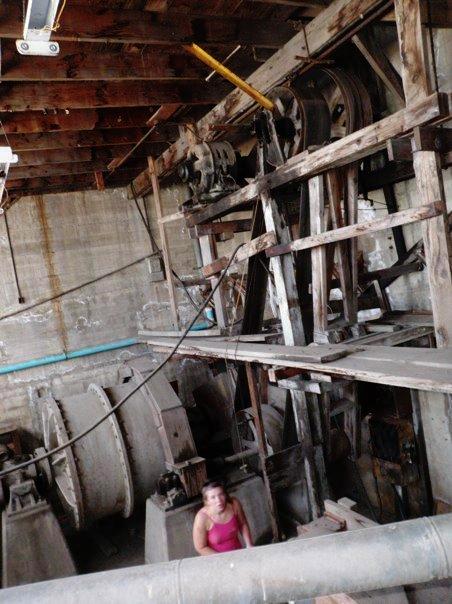
Below are some photos from inside the mill, the big white building.  It is a really cool old place.  And yes that is a bottle of nitric acid, although it is now empty.


So that's the story of the Salem Dream Mine.  Is it true?  Will it save the US economy?  Is there buried gold in the mountains around Spanish Fork?  I guess only time will tell.  However, if you ask people around Spanish Fork, most will tell you the gold is really there.  Even the book store in downtown Spanish Fork promotes the Dream Mine.


If you'd like more information on the Dream Mine, you can look at this Utah History Encyclopedia article, this Utah History Encyclopedia on the history of Salem, the relief mine's facebook page, reliefmine.com, or this article from reliefmine.com.  The last article is really interesting and is by far the best history of the Dream Mine that I have read anywhere.

Sunday, March 6, 2011

Sugar Beets Anyone?

I have to admit that this entry has been one of the most frustrating to find any information on.  Besides the windmills at the mouth of the Spanish Fork Canyon, one of the most iconic sites is the old Spanish Fork sugar factory.  I found these pictures of the old building.  The top one said that it was from between 1880-1920, and I am guessing the second one is from around 1920.

Photo courtesy of the L. Tom Perry Special Collections, Brigham Young University

Used by permission, Utah State Historical Society, all rights reserved.

There wasn't any information about the building while I was there photographing it.  When looking on the internet, I couldn't find very much information on it at all.  I did find several tid bits, but nothing specific.  From what I could find, the sugar beet industry in Utah County started in Lehi in the late 1890.  Most of the factories were owned by the Utah-Idaho sugar company.  The factory in Spanish Fork was built in 1916.  The plant was transferred from Nampa Idaho to the Spanish Fork area.  The plant was designated as a beet slicing factory and then the beets were shipped to Lehi via pipe.  The factory was able to grind 450 to 500 tons of beets per day, 50 tons more than the Lehi factory.  The pipe from Spanish Fork to Lehi was, at the time, the longest pipe used for transferring beet pulp in the nation.  Trains were an important park of the beet industry, and several lines were extended into Spanish Fork (and possibly down to Payson) for the shipping of sugar beets.  There were several factories around the valley, including factories in Payson, Springville, and Provo, although the one in Spanish fork was one of the largest in the state.  The only other information that I could find was that in 1925 there was a fire which caused between $500,000 and $850,000 worth of damage (although it could have occured at one of the other factories in the area) and an account from 1952 stated that during that year the factory was closed, although I don't know when it closed or if it ever reopened.  Besides that, I couldn't find any information about what happened to the factory or when it shut down.

Not only did I have trouble finding information, I also had trouble finding the location of the first photo.  The second one was taken accross the freeway from the factory.  Here it is as found today: 


If you look closely, you can tell that the factory has undergone some slight changes since the 1920s (its easiest to see the changes in the center of the building).  I believe that the building in the first photo was also renovated so it doesn't look quite like it did.  Either that or the original building was destroyed at some time.  Here is the only place that the picture could have possibly been taken from:


I couldn't copy the original angle because there are now huge silos located where the original photographer would have stood.  The whole factory is currently owned by Wasatch Pallet, inc.  It is really cool.  I would recommend checking it out.  I think that it may have had a fire at sometime (the back side has charcoal remains around all of the windows).  Here are some of the other photos I took while wandering around the property:


As for whats happening to this property, I have no clue.  It was a struggle to find any information on this building (if anyone knows anything else, please fill in any gaps in missing information).  However, there is some stuff occurring in the area that I have been wanting to mention.  Anyone driving on the I-15 would have noticed the tons of construction going on from Lehi to Spanish Fork.  Utah Department of Transportation is widening the freeway, redoing several overpasses, creating a few under passes, and doing a lot of other projects.  For more information, click here.  Also, if the project is completed under budget, the freeway will also be widened from Spanish Fork to Payson (and from what I can tell, the project is under budget right now).  So soon right next to this building there may be a three lane freeway.  I know, not too exciting, but probably for people who live in Payson.