Thursday, March 31, 2011

A couple of Springville Houses

     Today I wanted to highlight a couple of houses located on the west side of town.  The first one is the Kelly House, located at 164 W 200 S in Springville.  Here are two pictures of the house from 1905:

 Photo courtesy of the L. Tom Perry Special Collections, Brigham Young University

Used by permission, Utah State Historical Society, all rights reserved.

     Before discussing the Kelly House, the history of Springville needs to be discussed a little.  The settlers in Springville originally settled the town for the purpose of turning it into a farming community.  However, the were immediate problems when, during the first couple of years, there was large water shortages.  Many of the locals had to turn from farming to other industries.  One of the main industries that was started was construction.  Even though Springville had a small population of a couple thousand, it surpassed both Salt Lake and Ogden as the center for construction contracts.  The industry in Springville brought a lot of wealth, and several of the buildings that were constructed at the turn of the century, including the Kelly House, reflect this increase in wealth. 
    Thomas Kelly settled in the Hobble Creek area of Springville in 1853.  His family was a notable one in the area of Springville.  Kelly later became a school teacher and operated a few of the business in downtown Springville.  Kelly met and married Ella and in 1903 began to build his home on Depot Street (200 South).  Depot Street was the main street from downtown to the train station.  The house is built in the Victorian Style (for more information about his specific design, click here) and is especially notable since it is different than many of the houses that were being built at the time.  Kelly used a book for house design to incorporate a unique design to his new house.  In 1914, Ella died and Kelly moved from Springville.
     After Kelly's departure from Springville, the house passed through several owners.  In the 1930's it went through a little remodeling, which included the construction of a car garage.  In 1980 it was once again purchased and underwent a large renovation in 1981.  This included the complete back addition to the house.  In December of 1983 it was added to the National Register of Historic Places.  Here is what the building looks like today:


     Right across the street from the Kelly House is the Groesbeck House (157 W 200 S).  Here is a picture of it from around the turn of the century:

Photo courtesy of the L. Tom Perry Special Collections, Brigham Young University

     When researching this house, I couldn't find any information.  I found some scattered information about the Groesbeck family, such as N.H. Groesbeck was one of the first merchants at the Springville Co-op, there was a adobe theatre called the Goesbeck Theatre on Main St. that was destroyed in 1868, and that N.H. Groesbeck probably adopted some Indian children.  Besides that, I can't find anything.  I think that this house may be a little bit older than the Kelly house.  However, if you were to look at the house as it currently is, you might be just as confused.  Here is a picture of it:


     Don't worry, you can be as confused as I was.  The house has the same shape, but if you look at it, it doesn't look anything like the original picture.  I thought that may be the original was demolished or that I had the wrong address.  However, there is a plaque on this house stating that it is the Groesbeck Home.  It was added to the National Register of Historic Places in 1998.  I have no clue what happened to it because it doesn't look anywhere as nice as it used to.  I think that the reason why I was so shocked is that it is right across the street from the Kelly House, which has been extremely well preserved.  I just wish that the Groesbeck house was just as well preserved.

Wednesday, March 30, 2011

Springville Carnegie Library

     The first three years of high school I attended Livermore High in Livermore, California, a nice town about 45 miles east of San Francisco.  I think it was my sophomore year when we were learning about US history and I learned about Andrew Carnegie.  I heard that Carnegie, rather than giving off his money as an inheritance, decided to donate the majority of his money to different projects around the country.  I was especially surprised about a week later when I was downtown and found out that Livermore had been the recipient of one of those donations.  They had a nice park called Carnegie Park with a cool historic building in the middle.  Well, this week I found another such building, right in Springville, Utah.
     Carnegie immigrated to the US in 1848 with his family and settled in Pennsylvania.  He worked his way up through the steel industry and eventually become known as the second richest man in history after John D. Rockefeller.  He is also known as the "Patron Saint of Libraries."  He donated funds which supplied the financial backing for 1689 libraries across the US.  All that was required was that the city demonstrate a need, provide the land, books and librarians and pledge an annual 10 percent match to cover maintenance.  Twenty three such Carnegie libraries were built in Utah.
     On November 9th, 1916, the city of Springville become the 19th city in Utah to receive a grant from the Carnegie Corporation.  The grant totalled $10,000.  The library was designed by the architecture firm Ware and Tragenza (possibly spelt Tregenza) who had previously designed the library in Mt. Pleasant and would eventually design the libraries in Lehi and American Fork.  The architects designed the library using the prairie style, the architectural style made famous by Frank Lloyd Wright (an interesting side note on prairie style buildings.  I heard that one of Wright's assistants was from Utah, and after working with Wright returned to Utah to live and work.  That is why Utah has one of the highest concentration of prairie style buildings outside of the Midwest.  If you look around town, you'll find buildings everywhere built in this style.  For more info on prairie style architecture in Utah, click here).  The building opened in 1922.  Here is what it looked like in 1937:

Used by permission, Utah State Historical Society, all rights reserved.

     Eventually the library was moved elsewhere in Springville and the building became the home of the Springville Chapter of the Daughters of the Utah Pioneers (DUP).  I don't know exactly when it happened, but I found an article from the Deseret News stating that in 1989 the building was already being used by the DUP.  Here is a picture of the building as it currently is found (at 175 S. Main Street):


     It is a pretty cool building and is currently part of the National Register of Historic Places.  There are a bunch of tile on the top which give it an art deco/Native American feel.  You can tell that not much has changed since the 30's.  One of the significant differences is the statues around the building, which include a nice one a girl watering the flowers and Mark Twain which is fun to sit next to (which I always found ironic because he wasn't a fan of Utah).  Here are the statues:


     While walking around downtown, I noticed a lot of construction going on at the corner of Center and Main St.  I was wondering what it was and eventually came across the information that it is going to be the new Springville library.  It looks like a great building and will be a great addition to Springville.  For more information on it, click here or here.

Tuesday, March 29, 2011

Patrick L. and Rose O. Ward Home

    Located at 511 S Main Street in Springville is a really cool house built at the turn of the century called the Patrick L. and Rose O. Ward Home.  Here is a picture of it from sometime around 1900:

Photo courtosy of the L. Tom Perry Special Collections, Brigham Young University

     Patrick Ward and his family immigrated to Utah from Ireland to work on the railroad.  It is rumored that he came to Springville to finish the railroad line that went through Spanish Fork Canyon.  For many years they were the only Catholics in Springville.
    At the turn of the century, a really nice house was built for Ward and his family.  The house was built by Lewis J. Whitney and Andrew Pierce.  There is a little bit of discrepancy about when the house was built.  A plaque on the house lists its construction date as 1900 (as do a couple of websites on the internet) although the National Register of Historic Places Registration Form lists the construction date as 1910.  I think that the family in the previous picture may actually be Patrick and Rose Ward with their children (although I have nothing to confirm that).  The house is  a great example of the late Victorian architectural style.  It is rumored that this house was either the first or the second home in Springville to have running water inside in addition to an indoor bathroom.  The house was placed on the National Register of Historic Places in 1998 (although I did find a source listing the date as 1997).  Here is a picture of the house as it currently is found:


     The property is currently privately owned and has been turned into a nice boutique shop called "The Wandering Wardrobe."  I haven't shopped there at all, but the owners are really nice and so I'm sure it is a pretty nice store.  It is a really well preserved building and it looks great.  I totally recommend going to check it out.

Monday, March 28, 2011

Springville High School and Art Museum

It is always a little difficult to trace history, especially when the history has been destroyed and replaced with something new.  I had this problem this last week after I found the following two pictures of the Springville High School, the first one from around 1908, the second from around 1912, and what the location currently looks like.

Photo courtesy of the L. Tom Perry Special Collections, Brigham Young University

Photo courtesy of the L. Tom Perry Special Collections, Brigham Young University


If you look closely, you will notice that the original building from 1908 sits on the right side of the building from 1912.  I talked with several individuals from Springville who couldn't come to a consensus about these two buildings, where they were located, or if they were even the high school.  However, through the use of several photographs of these two buildings and the help of a couple of long time Springville residents, I found out that this is in fact the old high school and that its location is currently found directly where the Springville Art museum parking lot is located.

The history of the high school was really difficult to find and in the end, I didn't end up with very much information.  The original high school was probably built around the 1900's.  Eventually they expanded it with the addition of the second building.  The two buildings were connected by a hallway.  Several people informed me that the older of the two buildings was the junior high.  What probably happened was that the older building was originally the high school, eventually an expansion was needed, and once the expansion was completed the old school became the junior high. 

Before the BYU women's gymnasium was built the BYU basketball team would occasionally compete in the Springville High School Gym.  The buildings were torn down sometime in the early 80's and the high school was relocated to the current location, 1205 E 900 S.  It is possible that the school was moved in the 60s and that the old buildings were demolished in the 80's.  The reason for this is that the wikipedia page for Springville High reports that the mascot had been the red devils since 1967.  This mascot, although controversial, originated from the Red Devil Cement Company, and I have heard that this company made the bricks that were used to build the high school.  If that story is true, then it would make sense that the new school was built in the 60's.
   
Another photo that I found regarding the old high school is the Springville Art Museum which is located next to the old high school.  Here is an undated photo that I found of the museum and what the building currently looks like

Used by permission, Utah State Historical Society, all rights reserved.


The museum began in 1903 when two individuals donated pieces of art to the Springville High School.  During the early 20th century, donations were continually given to what was known as the Springville Art Gallery in addition to exhibits that occurred there from time to time.  In 1935, the museum's collection had grown so large that a new building was needed to be constructed.  The high schoolers and townspeople raised $100,000 dollars to construct the building.  The remaining funds were provided as part of the Public Works Administration, the organization during the great depression that intended to get people back to work.  The museum became Utah's first for visual arts.  Upon its dedication in 1937 by LDS Church Apostle David O. McKay, he said that the building is a "sanctuary of beauty and a temple of meditation."

The Springville Art Museum has played a central part of Springville's culture over the past 100 years.  Today, Springville is known as "Art City" and statues line main street and any other corner in the city where room can be found.  The Museum, which was built in a Spanish Moroccan style, is currently part of the National Register of Historic Places and is listed under Springville High School Art Gallery.  The museum has expanded twice since its construction, with the most rescent addition doubling its size.  It is a really cool place and I would recommend anyone going to visit.  My sister had her wedding reception there and it was amazing (several people would argue that it was the best reception they had ever been to).

An interesting side note is that I think that this museum is still owned by the school district in Springville, which is the Nebo School District.  Besides the art museum, the only other building that remains from the old high school is the seminary building across the street.  The building has since been turned into the Springville Genealogy Library.  Here is a picture of it:


     At the corner where the old high school used to stand, there is a nice stone bench that says "For the Youth of Springville."  I don't know if the bench was placed there in memory of the old school, especially since I can't find any other reference in the area towards it, but I would like to think that it is.  I hope that the bench serves as a memory of all the people who have gone through the old Sprinville High and all the other students who are yet to come.

Thursday, March 24, 2011

2nd Ward Chapel in Springville

Today's post is about the 2nd ward chapel in Springville.  In 1892, Springville was divided into 4 wards and a chapel was built for each ward.  The 2nd ward built their chapel at 451 S Main Street.  A historic book in the Springville Family History Library states, "The second ward LDS church is a beautiful brick building, built in 1904, costing over $10,000.  Bishop Adnerson was the driving force back of the construction of this building.  He resigned at the end of the year 1901 and J.F. Binghurst was appointed to replace him.  There were over 800 people in the ward at this time." 

Here is the building from around 1900:

Photo courtesy of the L. Tom Perry Special Collections, Brigham Young University

     The building was scheduled to be demolished in the 90s, but was people decided to save the building due to its unique architecture.  It was remodeled in 1998 at the cost of 1.5 million dollars and was rededicated by LDS Church President Gordon B. Hinckley.  However, in July of 2006, a fire broke out in the building.  The Daily Herald reported that "Vandals broke locks, sprayed fire extinguishers, broke pictures and caused other damage inside the building before setting fire" in the cultural hall after entering through a window on the second floor.  They estimated that around $200,000 dollars worth of damage had been done.  Here is a picture of fire fighters in front of the building from the Deseret News:

Photo courtesy of the Deseret News

It was decided that the building would cost too much to be repaired and that it should be demolished.  Before the building was destroyed, some of the glass windows were removed and put in another church in Springville.  Here is the location as it is found today:


When researching this site, I found that there has been recent push to develop the property.  Some individuals approached the Springville City Council asking to turn the site into residential subdivision.  I think the plan is to turn it into a residential and commercial area called Charity Condominiums.  There may have been plans to turn it into a elderly rest home, but I think that the Charity Condominiums idea is catching steam and it may even have gotten approval from the Springville City Council.

There is another really interesting development in the destruction of this chapel.  The Deseret News reported this last December that a man named Jake Devin Dowhaniuk has been charged with the arson of the building.  Dowhaniuk is currently in the state prison in Gunnison for burglary and disorderly conduct.  There were traces of blood found at the burnt chapel in 2006 and a recent DNA test matched it with Dowhaniuk's blood.  The Deseret News reported that there may have been more individuals involved in the crime due to the extensive amount of damage.

Monday, March 21, 2011

The Arrowhead Trail, Highway 91, and I-15

One of my favorite things to do is to tell people directions to my parents house.  My parents live 700 miles away but the directions are about as easy as how to get to my sisters house, a measly 7 miles away.  All you have to do is get on the I-15, head south till you get to San Diego, take the Carmel Mountain exit, and after a couple turns you are at their house.  Its that simple.  The I-15 has made giving directions to Southern California incredibly easy.  A couple of days ago, I went out to the I-15 to watch Utah Department of Transportation crews lift a new bridge into place over the I-15.  It made me think a little bit about its history and so this entry is dedicated to that great road.

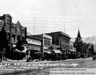
Although I am not sure that there was some trail from Salt Lake City to Los Angeles in the early 20th century, in 1915 the Arrowhead trail was established as the first all-weather road connecting between the two cities.  The road ran through Las Vegas and is now part of what Las Vegas Boulevard.  A sign placed by the Nevada State Historical Society says:

 "Las Vegans claimed to be the originators of this all-weather route between Los Angeles and Salt Lake City.  From the beginning, the Arrowhead Trail was a 'grass roots' effort including promotion by the various chambers of commerce and volunteer construction by local citizens.  However, it was Charles H. Bigelow, from Los Angeles, who gave it great publicity.  During 1915 and 1916 he drove the entire route many times in his twin-six packard 'Cactus Kate.'" 

The only picture of the original trail that I could find comes from a section of downtown Cedar City, with the road right right down the middle of town:

Photo courtesy of the library at Souther Utah University

In 1926, when the federal highway numbering system was established, the Arrowhead Trail became Highway 91.  From what I can read, Highway 91 followed the same route as the Arrowhead Trail.  The road ended in Long Beach, and to the north it went as far as Alberta, Canada.   Here is a map of the original Highway 91 from 1926 in addition to a picture of the construction of Highway 91 in Cache County:

Photo courtesy of the website www.wchsutah.org/roads/highway-91.htm

Used by permission, Utah State Historical Society, all rights reserved.

In the 60's and 70's it was decided that a new road needed to be put in its place, which eventually became the I-15.  The I-15 covers the same area as Highway 91 and in some areas was built directly on top of it.  Two major differences is that it did not go through Logan and also cut through the Virgin River Gorge, making the traveling time from Las Vegas to St. George much quicker.  The final section of the road was completed in 1975 and it is currently the 4th longest north-south interstate highway in the US.

After I-15 was built, some areas of Highway 91 fell into disuse.  I found a picture of a plane using the old road just north of Cedar City as a runway in 1970:

Photo courtesy of the library at Souther Utah University

For the last 40 years, the I-15 has been the primary north-south viaduct in Utah.  In recent years, there has been a large population growth throughout Utah.  As part of UDOT's plan to support this growth, there has been lots and lots of construction along the I-15, most recently in Utah County.  The construction in Utah County is known as the I-15 Core, which is the largest construction project undertaken by the state of Utah.  This project mainly calls for widening the I-15 and using concrete instead of asphalt (which will be great cause it will cut down on potholes), it also includes rebuilding and reconfiguring 10 freeway interchanges and replacing 55 aging bridges.  One of these bridges is the Sam White bridge which, at 354 feet long, will be the longest two-span bridge ever moved in the western hemisphere.  It is really cool to watch them move it since it is moved into place with huge hydraulic lifts.  If you want a movie of it, just click below.


     I went the other night to watch another bridge by put in place in Pleasant Grove.  It was pretty cool, just to watch the machinery at work and how many people it took to do the whole operation (probably around 100).  Here are some pictures from that trip:


    I did find some interesting pictures of the Highway 91 as it is today.  For a cool website of the old Highway 91 by Idaho area, click here, and for some cool pictures down by St. George, click here.

Sunday, March 20, 2011

Jefferson School

In 1901, Jefferson School was built at 757 S. Main Street in Springville.  The school was built using a Victorian Romanesque style and out of the couple of schools that were built around the same time, the Jefferson School is the only one that is still standing.  Here is a picture of it from the early 20th century and what it looks like today:

Used by permission, Utah State Historical Society, all rights reserved.


When the school was built, there were also 2 other schools built, although they have since been demolished.  This was due to the population growing towards the east side of Springville.  All three buildings were built around the historic main street district.  There used to be a fort located on the west side of the building, this may have been located where the large grass field currently is.  I'm not sure when the school closed, but I did find an article online where a Springville councilman told of story about when he attended the school during World War II.  I think I may have even found on classmates.com several people who attended the school in the 60's and one who even attended it in the 1980's.

Luckily the school has been preserved quite well.  In 2004, it became part of the National Register of Historic Places as part of the Springville Historic District.  The south boundary of the district is Jefferson School.  The school was converted into an office building as is currently occupied by Red Cliff Ascent Treatment Centers.  Red Cliff Ascent is a residential treatment center, specializing in outdoor activities for at-risk youth.  I don't know if they actually use the building as a housing complex, but I do believe that youth occasionally visit it, as the field to the west of the school is, I believe, owned by Red Cliff.

You may have noticed a couple of things by looking at the two photos.  The building now is larger than the original photo.  Sometime after the original photo was taken, the back half of the building was added.  Also, the building is no longer called Jefferson School or Jefferson Elementary but Jefferson Center.  If you would like a cool view of the whole area around this school, click here.

Saturday, March 19, 2011

Springville Presbyterian Church block

OK, so I'm back.  Sorry for the short break, but I had some stuff to do this last week.  Here is the a photo that I found from 1892-1895 of the Springville Presbyterian Church and how the church looks today:

Photo courtesy of the L. Tom Perry Special Collections, Brigham Young University


This site is also on the National Register of Historical Places.  The plaque in front of the church states:

"In 1877 the Rev. George Leonard established a Presbyterian church and mission school in Springville.  In 1892-1893, this church was built just south of the Presbyterian Hungerford Academy, the only school then providing education from elementary grades through high school for all denominations.  This church is an example of the late gothic revival style with a Romanesque revival bell tower.  The stained glass windows are part of the original structure.  The building has served as a Presbyterian church continuously since its construction."


There is now a backside of the church that was added in the 50's.  The plaque mentions the Hungerford Academy.  Here is an old picture of it and what the site looks like today:

Photo courtesy of the library at Westminster College, Salt Lake City


When I went to the Presbyterian Church, I met some really nice ladies who let me take a tour inside.  It is really pretty, and I would recommend anyone to visit it; the address is 245 South 200 East.  Below are some pictures from inside the church.  The first is from a room on the second floor.  It probably used to be used as a bride's dressing room.


Below is an area that used to be a whole separate room and was used as kitchen.  It has since been altered and is now part of the chapel.


Below are the stairs leading to the second floor and some beautiful stained glass.  A few years back the original stained glass had to be replaced.  In order to keep it on the National Register of Historic Places, historic stained glass had to be used.  Upstairs there is also a bell which is still rung on Sundays.  They stopped ringing it for a while and Mormon people in the neighborhood started to complain.


I learned a couple of other interesting facts from the nice ladies inside.  The teachers at the Hungerford Academy weren't allowed to be married.  There was also a show called "Promised Land" which was a spin off of "Touched by an Angel" and the house that was used as the family's home in the show is the old abandoned house across the street from the church.  Back in the day, the church owned the whole block.  All of the buildings have been demolished except for an old building on the south side of the block that has since been converted into an apartment building.  Here it is:

Monday, March 14, 2011

Spanish Fork (aka Gopherville) Pioneer Cemetary

I wanted to spend one last day on Spanish Fork so that I could focus on a cool place found in the city.  I found the following photo from 1968 of a couple at the Pioneer Cemetery in Spanish Fork.

Photo courtesy of the library at Southern Utah University

The cemetery is located at about 1400 E 1820 S.  When pioneers first arrived in Spanish Fork, they lived in dugouts, which were houses dug into the ground; I assume they are pretty similar to the foxholes used by soldiers.  So many people were living in dugouts that the city was nicknamed "Gopherville."  People used this original cemetery to bury the people that died during the 1850s and 1860s.  After the 1860s, the main city cemetery was moved and the pioneer cemetery fell into disrepair.  I found an entry on the internet from the 60's that said that the area wasn't being cared for and that it was a sad sight.  Slowly the cemetery was forgotten about and became a big cattle field full of weeds.

Recently, a development agency decided to build houses around the cemetery.  As part of the project they restored the cemetery, built a fence around it, and added a really nice statue.  Articles about it can be found in the Deseret News here and here.  Here is a picture from 1400 E just about the riverbottoms:


The cemetery is located within the gray stone fence just to the right of the sign.


The cemetery is located on a beautiful bluff above the river bottoms and has a great view of the valley.  The huge stone memorial that was in the original picture has been removed and the plaque that was part of it was placed on the left brick support column of the entrance arch.  It was originally placed in the cemetery in 1941 and it reads: "Pioneers were buried here between 1851 and 1866 when this cemetery was abandoned."  It then lists about 15 pioneers who were buried in the cemetery.  On right brick column of the arch is a plaque commemorating the cemetery.  It says:"Utah South Center Company Daughters of Utah Pioneers, in conjunction with the City of Spanish Fork, community donors, and volunteers have reclaimed and resorted this hallowed ground in remembrance of the pioneers who persevered through uncommon hardships because they had faith in their God and in their cause.

"... The first settlers arrived in 1850.  Their life and death struggles while facing hunger, hostile natives, disease, grasshoppers, and crop failure are heroic and heartrending....  Their valiant examples of strength and courage have left a legacy to be treasured.  May this sacred and hallowed ground be a place of rest, reflection, and reverence."

It really is a great place to reflect on the people who came to and settled Utah.  I have been thinking a lot about this lately because of my grandma who passed away a couple of weeks ago at the age of 98.  She is the relative of a person who was in the famous Mormon handcart company who became trapped in what is now Martin's Cove in Wyoming.  Around 1/4 of the pioneers in this group, known as the Martin handcart company, died from starvation and hypothermia while awaiting rescue on the plains in Wyoming.  One of the people in the company was my relative (sorry I don't know his name).  If I remember the story right, he, his mother, and I believe 5 of his siblings survived while his father and a newborn baby both died.  My relative ended living quite a while and actually told my grandmother stories of when he was starving out in Martin's Cove in Wyoming. 

I know that Utah has changed dramatically from the pioneer days of the past, but sometimes it is amazing how close the past is, such as a grandma who actually talked and heard stories from a member of Martin's Handcart Company.  While I was looking through the pictures of Spanish Fork, I found hundreds of pictures of old pioneers.  While it is cool to look at buildings and old historic places, I think it is also important to remember the people that built the buildings or participated in the events which made a place historic.  Whether you have pioneer ancestors or you are a transplant to Utah, it is important to remember the people who struggled across the plains to settled this great place where we now live.

Sunday, March 13, 2011

National Register of Historical Places in Spanish Fork

Over the last couple of days I came across the National Register of Historic Places for Utah .  In Utah County, there are 172 locations on the list.  I wanted to talk about the two places in Spanish Fork that are found on that list.

The first is the Spanish Fork High School Gym, which I talked about in a previous blog post.  This was added to the National Register on April 1, 1985.  The gym was placed on the Register because of its importance in the art deco style.  The building was built in 1934 and is now part of the Nebo School District Office.  Here is a picture of what it looks like today:


The other building on the Register is the David H. Jones House which is located at 143 S. Main.  This building was added on October 24, 1985.  The plaque located on the house says,

"This craftsman bungalow was built c. 1912 for David H. and Mary E. Nielsen Jones, who lived here until their deaths in 1959 and 1976, respectively.  In addition to running his own farm and livestock operations, David Jones served as Commissioner of Agriculture for Utah, as president of the Utah State Farm Bureau, and as president of the Utah County Cooperative Dairy for 20 years.  His political career included six years of service as a Spanish Fork city councilman and two terms as a state senator." 

Here is the building as it is found today:


One of the coolest things about this property is that several pioneer era buildings are located on the property recreation of pioneer era buildings; the pioneer buildings are located in what is called Pioneer Park.  I found a great article online that describes this area and the history behind it:
        
"On 143 S. Main Street there is an old home that has been completely renovated. It belonged to David H. Jones who built it in 1911-1912. Now Jones's granddaughter, Elaine Jones Hughes, and her husband J.P. own the home, and have worked to turn the entire property into a sanctuary of the pioneer past. Through the years, Elaine and J.P. have worked to acquire and move several pioneer cabins and other buildings onto the property, and they open it up to the public. Elaine said they consider themselves in a small way, curators of the past, and they love to share what they have learned with others.

"The park is open every July 24 for the public to come and see first hand authentic pioneer antiques and cabins, but Elaine clarifies that they don't actually open their house for touring.

"The property is also the place for the Fiesta Days quilt show. Elaine said the quilts are beautiful draped along the property, and even hung directly on to the house.

"'We especially like to have pioneer quilts hung on the house.' Elaine said.

"Some years the Hughes family has had blacksmithing, soap making, spinners, basket weavers and other pioneer craftsmen at work at the park on July 24.

"The first log cabin on the site was donated by the Henry/Hansen family over 15 years ago. Their pioneer ancestors, Peter and Elena Hansen on Spanish Fork built it, and the Hansen family wanted to preserve it, but needed the property where the cabin was situated for other purposes, so they donated it to Elaine and J.P. who moved it to their property.

"Another cabin on the site belonged to Archibald Gardiner from Salt Lake, but his son Neil Gardiner, was a prominent Spanish Fork citizen so the cabin was moved to the Spanish Fork site as well. Archibald Gardiner is the great[great paternal] grandfather of J.P. Hughes.

"Another cabin on the site was belonged to David Abbot Jenkins (Ab Jenkins), and it is the second oldest log cabin in Spanish Fork history. Ab Jenkins was born in the cabin in 1883. The Hughes family turned this cabin into a cobbler show with authentic cobbler tools and tables. It was dedicated at the 2006 Fiesta Days Celebration on July 24, 2006.

"There is also a mill at the site that came from Leland and a pump house that had its origins in Salt Lake.                


Saturday, March 12, 2011

Downtown Spanish Fork (and may be a couple broken wrists)

I wanted to start off with a word of advice for all people that want to take pictures from on top of roofs.  While in Spanish Fork, I needed to take a picture from on top of a roof in the downtown area.  I scouted around the back of the buildings trying to find some place suitable for me to scurry up.  I found what I thought was the perfect pipe that I figured that I could crawl up like Pacific Islanders do up a palm tree.  I started up and got to the very top of the pipe when I realized that it wasn't securely attached to the wall.  It started coming loose and I fell a good 15 feet onto my heel, butt, and wrists.  This last week I have been recovering, but I've got some great news for the doctor: nothing is broken!  Here is a picture of the pipe in Spanish Fork that I tried to climb.  You can see it going diagonal from the power box to the telephone pole.


I wanted to climb onto the roof to duplicate a picture of downtown Spanish Fork form 1914.  He is that picture and what the area looks like today:

Photo courtesy of the L. Tom Perry Special Collections, Brigham Young University


This picture is taken between 1st and 2nd North looking west.  There are only two buildings that were in the original photo that still stand: the Booth Block building (the third building from the right) and the Bank Building which was built in 1891 (in the bottom picture, it is about 1 1/2 blocks down and is white with brown adornments towards the top).

Another important building in downtown was the Oran Lewis Store, which is also located between 1st and 2nd North on the west side of the street.  Here is a picture of the store as it looked in 1875 and how the building looks today:

Photo courtesy of the Provo City Library


I am happy that this building is still around, as it is probably the oldest building in downtown (and I believe may be the oldest building, besides some of the houses, in Spanish Fork) although I hope that someone will put some money into it to restore it because it looks pretty ugly as it is.  I think that this building has been used as a grocery store for several years.

The final building in Spanish Fork is the Co-op store.  I found two separate pictures of the a couple different stores that were called the Co-op.  The first is found in the picture below, which is of a building is from between 1890-1894.  I believe that this was the original Co-op and was located on the corner of 1st N and main.

Used by permission, Utah State Historical Society, all rights reserved.

What I think occurred is that the original Co-op was eventually demolished or expanded into a larger Co-op, which can be seen below, in addition to what the area looks like today.

Used by permission, Utah State Historical Society, all rights reserved.


In the most recent photo, the building on the left is what is called the new co-op building.  I don't know when the old one was demolished, but I don't think the new one looks nearly as nice.   I believe that the building to the right of the Co-op has been remodeled and is the building with the large brown siding covering half of the front.

There is one other photo which involves this co-op building.  The following picture is of the Orem-Salem interurban rail line which went right down main street.  Here is the original photo, which is from 1914 and how it looks today:


From what I researched, I think that this rail road line may have had an important role in sugar beet production (click here for an older blog about that).  I think the line went from Orem to Payson and somehow snaked over to Salem and was mainly used to transport sugar beets either to or from this area.  

Although there are a few old historic buildings left in Spanish Fork, I am pretty disappointed with how many have been torn down and replaced, especially since several of the buildings have been replaced with ugly buildings.  I just hope that in the future, the few buildings that they do have left will be preserved.